
The temperature at DFW Airport hit 105 degrees on Wednesday, establishing the hottest temperature so far in 2023. And we have more heat on the way over the next 10 days, although some may see scattered showers and storms through Sunday.
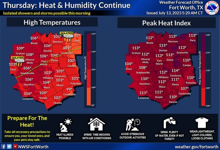
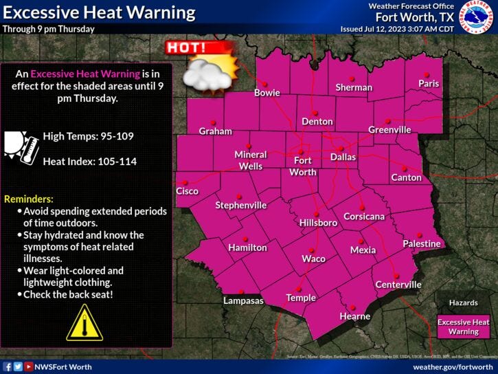
An Excessive Heat Warning is in place across all of North Texas Thursday with afternoon highs between 102° and 107°. The heat index value will exceed 110° during peak heating hours. There's also a slight chance of showers and storms after midnight towards daybreak Friday, especially north of Highway 380.
After the Excessive Heat Warning expires at 9 p.m. Thursday, a Heat Advisory will go into effect through 9 p.m. on Friday for all of North Texas.
Afternoon highs Friday will reach 105° and heat index values will be close to 110°. There's also a slight chance of showers and storms early Saturday morning, especially north of the Dallas-Fort Worth area.
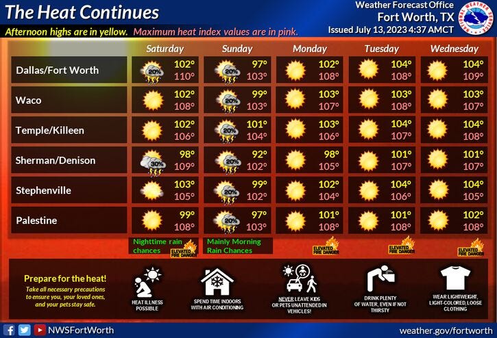
It'll still be hot on Saturday with afternoon highs in the low 100s. There's a slightly better chance for showers and storms after midnight into Sunday morning from DFW up toward the Red River Valley. A cold front will be responsible for this development late Saturday night. As of now, it looks like this front will slide south of the Dallas-Fort Worth area on Sunday dropping temperatures into the mid to upper 90s for highs.
There's one more chance of showers and storms late Sunday into early Monday before the ridge of high-pressure returns to the area. Afternoon highs on Monday will reach 103°. I'm forecasting highs between 104° and 108° next Tuesday through Thursday.
*Yest Rain: 0.00"; Yest High: 105: Low: 82
*Today’s Averages: High: 95; Low: 76
*Record high: 107 (1980): Record low: 64 (1990)
*July Rain: 0.15"; Deficit: 0.92"
*2023 Rain: 14.51"; Deficit: 6.85"
*Sunrise: 6:29am; Sunset: 8:38pm
Today: *Excessive Heat Warning* A few morning showers and storms, then mostly sunny, breezy, hot, and humid. High: 101-107. Heat index: 110+. Wind: South 15-25 mph.
Tonight: Fair, muggy and warm. A few morning showers north of DFW. Low: 78-82. Wind: South 15-25 mph.
Friday: *Excessive Heat Warning or Heat Advisory* A few morning showers and storms, then partly cloudy, breezy, hot, and humid. High: 101-106. Heat index: 108-112. Wind: SSW 10-20 mph.
Saturday: *Possible Heat Advisories* A few morning showers and storms, then partly cloudy and hot. Scattered storms (north of I-20) after midnight. High: 99-103. Heat index 105+.
Sunday: Morning showers and storms, then Partly cloudy and a tad cooler. A slight chance of storms by late evening. High: Mid to upper 90s.
Monday-Wednesday: Mostly sunny, heating up again. Heat Warnings and Advisories return. Highs: 102-107.
Related

LISTEN on the Audacy App
Tell your Smart Speaker to "PLAY 1080 KRLD"
Sign Up to receive our KRLD Insider Newsletter for more news