
Parts of north Texas got rocked by severe weather late yesterday evening and then again this morning. Things are calming down for now, but by late this afternoon, more scattered severe storms will break out across parts of north Texas.
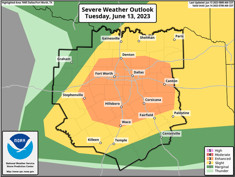
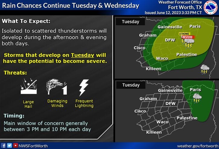
Here we go again: a level 3 out of 5 (Enhanced risk) is in place across north Texas. The storm threat will be between 4pm and midnight.
Threats: VERY LARGE HAIL and damaging wind. Tornado risk VERY low.
The Severe Thunderstorm Watch will be allowed to expire early this morning. The storms are now east and NE of north Texas, affecting the Red River Valley east of Sherman and into east Texas. Temperatures will struggle to get above eighty six today under a partly cloudy sky.
Please stay weather aware between 4 PM and midnight tonight, as more scattered severe storms will form along a stationary frontal boundary that's currently draped across north Texas. Some of these storms will contain very large hail and damaging wind. Please keep in mind, not everybody will see stormy weather.
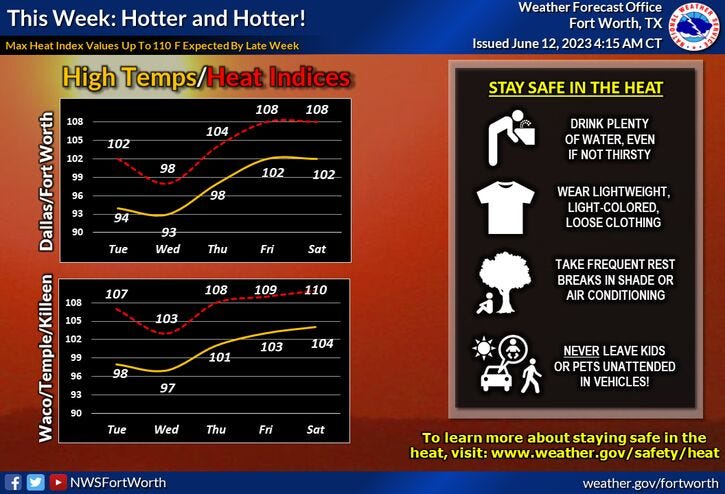
Starting tomorrow, the storm chances shut off and a big heatwave is on the way. A large bubble of high pressure will nose its way in from the southwest by the end of the week and especially this weekend and all of next week. We will experience our 1st triple digit heat of 2023 as well as widespread heat advisories. Temperatures will be above 100゚ this weekend and most of next week. Heat index values will be as high as 110 degrees starting Sunday!.
Please stay weather aware again late this afternoon at evening,...then we're done and the heat is on across north Texas!
Today: *Severe Thunderstorm Watch until 10am** Scattered morning and evening severe storms. Threats: Large hail and damaging wind. A break this afternoon. Staying on the cool side. High: Mid 80s. Variable 10-15 mph.
Tonight: Scattered evening severe storms, then mostly cloudy and mild. Threats: Large hail and damaging wind. Low: 68- 72. Wind: East 10 mph.
Tomorrow: Partly cloudy, hot and humid. High: Low 90s. Wind: ENE 5-10 mph.
Thursday: Mostly sunny and hot. Mid to upper 90s.
Friday: Sunny, hot and humid. High: Near 100.
Saturday - Monday: Sunny, hot and humid. Possible Heat Advisories. Highs: 101-104. Heat indices: 107-110.
Related

LISTEN on the Audacy App
Tell your Smart Speaker to “PLAY 1080 KRLD”
Sign Up and Follow NewsRadio 1080 KRLD