
A stationary front, scattered showers, above average temperatures, and a strong cold front. Those are your weather stories over the next 7 days.
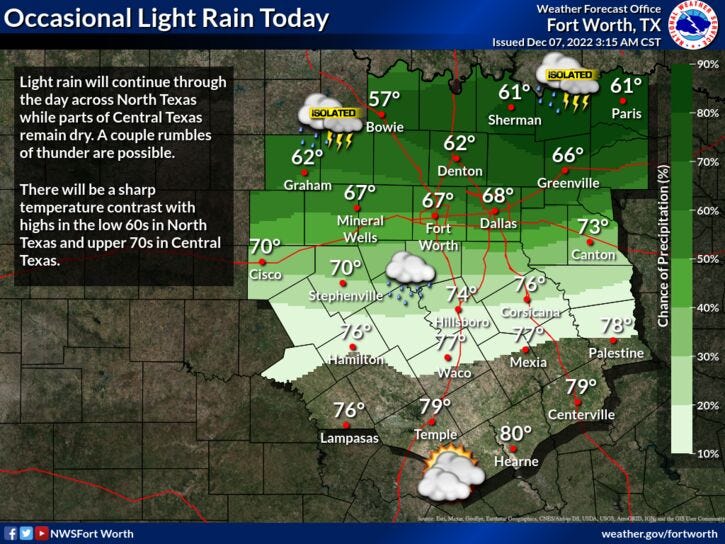
We're waking up to temperatures ranging from 54 to 69 across north Texas. A weak cold front has gone stationary just south of I-20 this morning. Temperatures are cooler north of the front and milder south. There's also a conveyor belt of light rain that will continue to work its way across North Texas through the day. Rainfall totals will be light. Afternoon highs will range between 58° and 70° across the area.
A few leftover showers are possible tonight with morning lows in the low to mid 60s.
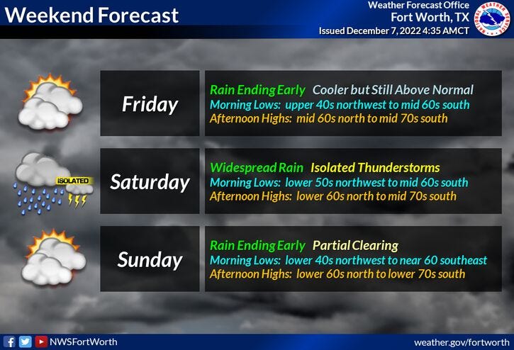
More scattered showers will develop tomorrow along another weak cold front. Afternoon highs will range between 65° and 73°.
Brief sunshine returns on Friday as well as slightly cooler temperatures. Afternoon highs will be in the low to mid 60s. Clouds will increase rapidly Friday night and there's a decent shot of showers and isolated thunderstorms on Saturday. Afternoon highs will be in the upper 60s.
Sunday looks relatively dry under a partly cloudy sky. Temperatures will approach 70°.
Monday will be partly to mostly cloudy with an isolated shower or two. It will also be very windy. Afternoon highs will top out near 70° once again.
More scattered showers are in the forecast for Tuesday, with highs near 70° again. By late afternoon, a very strong cold front will plow through the area, dropping temperatures to below seasonal averages for the rest of the week.
That's all I've got on this gloomy Wednesday morning! Enjoy your day and the weather when you can, it's the only weather you've got!
7-Day Headlines:
* DFW reached 77 degrees yesterday.
* Scattered showers today and tomorrow.
* Above average temperatures through the weekend.
* Rain returns Saturday and early next week.
* Strong cold front late Tuesday.
*Yest Rain: Trace; High: 77; Low: 61
*Today’s Averages: High: 60; Low: 40
*Record high: 84 (2007); Record low: 10 (1950)
*December rain: Trace; Deficit:
*2022 Rain: 34.25”; 2022 deficit
*Sunrise: 7:18am; Sunset: 5:21pm
Looking Ahead:
Today: Cloudy with on and off showers. High: 58-65. Wind: NE 5 mph.
Tonight: Cloudy, mild and muggy. Scattered showers. Low: Low 60s. Wind: South 5-10 mph.
Tomorrow: Cloudy with scattered showers. High: Low 70s. Wind: SSW 10-20 mph.
Friday: Partly cloudy, a bit cooler. High: Low to mid 60s.
Saturday: Mostly cloudy. Scattered showers and storms. High: Upper 60s.
Sunday: Partly cloudy and mild. High: Near 70.
Monday: Partly cloudy, windy and mild. Slight chance of showers. High: Low 70s.
Tuesday: Mostly cloudy. Scattered showers and storms. Strong late day cold front. High: Near 70.
Related

LISTEN on the Audacy App
Tell your Smart Speaker to "PLAY 1080 KRLD"
Sign Up and Follow NewsRadio 1080 KRLD