
Our brief cooldown is almost here, but we'll have to wait a couple more days.
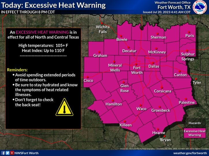
We hit 105° yesterday at DFW, our 13th triple digit day of the year. And we've got two more coming as afternoon highs top out near 104° today. We also have another Excessive Heat Warning in place for all of northTexas today. These warnings will change to a Heat Advisory tomorrow, as readings warm to 102° out and ahead of our fabulous cold front.
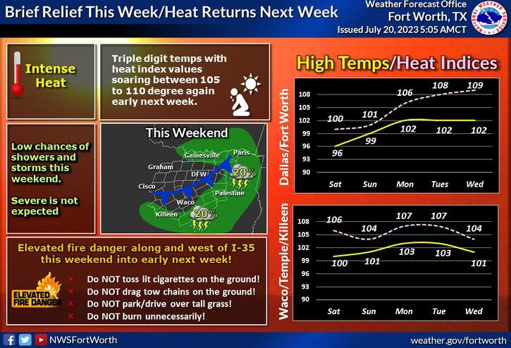
Unfortunately, this front will come through dry tomorrow afternoon, but it will knock temperatures down into the low 90s for Saturday. We can't rule out a few sprinkles around the area, especially east of the Dallas-Fort Worth area.
Our cool-down will be brief, as we rapidly warm up to near 100° on Sunday.
It gets worse than that next Monday through Wednesday, with afternoon highs approach 106°. This means that Heat Warnings will return to most of North Texas.
*Yest Rain: 0.00"; Yest High: 105 Low: 83
*Today’s Averages: High: 96; Low: 76
*Record high: 109 (2022): Record low: 65 (1920, 2014)
*July Rain: 0.47"; Deficit: 1.04"
*2023 Rain: 14.83"; Deficit: 6.97"
*Sunrise: 6:34am; Sunset: 8:35pm
Today: *Excessive Heat Warning* Sunny, breezy, hot and hazy. Grass fire danger. High: Near 104. Heat index: 106-108. Wind: South 10-15 mph.
Tonight: Clear, breezy and warm. Low: 80-84. Wind: SSE 10-20 mph.
Friday: *Heat Advisories possible* Partly cloudy, hot and hazy. Afternoon cold front. High: Near 102. Heat index: Near 105. Wind: NNE 10-15 mph.
Saturday. Mostly to partly cloudy and cooler. An isolated shower possible. High: Low 90s.
Sunday: Sunny, heating back up. High: Near 100.
Monday - Wednesday: Sunny and very hot again. Possible advisories and warnings. Highs: 103-106.
Related

LISTEN on the Audacy App
Tell your Smart Speaker to "PLAY 1080 KRLD"
Sign Up to receive our KRLD Insider Newsletter for more news