
We're waking up this morning to very mild temperatures for this time of the year. Our above average trend will continue for the next week, before a decent cold front will cool things down by the middle of next week.

In the meantime, temperatures are in the 60s this morning and nothing is showing up on radar. There could be a few showers around tomorrow morning and then again late tomorrow evening as a cold front stalls across the area and then lifts back to the north tomorrow late evening. There's no cold air behind this front, but readings may drop a couple of degrees for afternoon highs tomorrow. Readings will mainly be in the mid 80s today through next Tuesday, with morning lows in the 60s.
I do want to mention there's a slight chance for storms late Sunday and then again late Tuesday and Wednesday along our stronger cold front. This is when humidity levels will drop again and temperatures will dip to below average levels.
*Yest Rain: 0.00”; *Yest High: 81; Low: 59
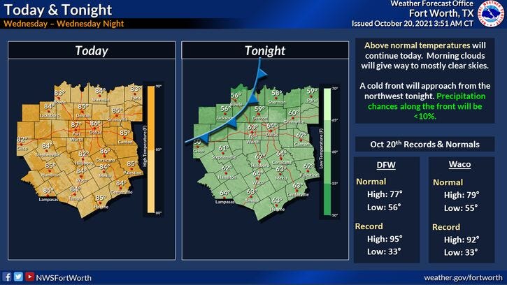
*Today’s Averages: High: 77; Low: 56
*Record high: 95 (1934); Record low: 33 (1989)
*October rain: 2.21”; October deficit: 0.28
*2021 Rain: 29.30”; 2021 deficit: 0.46
*Sunrise: 7.36am; Sunset: 7:49pm
Today: Partly cloudy and warm. High: Mid 80s. Wind: SSW 10-20 mph.
Tonight: Increasing clouds. A slight chance of showers towards daybreak. Low: 60 North to 70 South. Wind: South 5 mph.
Tomorrow: A few morning showers and then again by late evening. High: Low 80s. Wind: NE 5-10 mph.
Friday -Sunday: Mostly sunny, breezy and warm. A slight chance of showers and storms late Sunday. Highs: Mid 80s.
Monday and Tuesday: Partly cloudy, breezy and warm. Slight chance of storms late Tuesday. Highs: Mid 80s.
Related

LISTEN on the Audacy App
Sign Up and Follow NewsRadio 1080 KRLD