
Welcome to Monday ladies and gentlemen! I hope you had a terrific weekend!
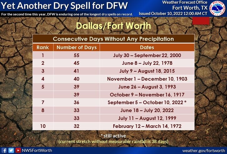
It's back to work in school we go... and there's not a lot going on this week in the world of weather.. I wish I had better news.. we need rain! As of yesterday, we've gone 35 consecutive days with no rain at DFW airport. That ranks number seven all time for rain-free streaks.
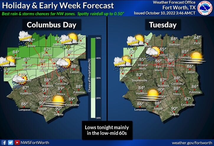
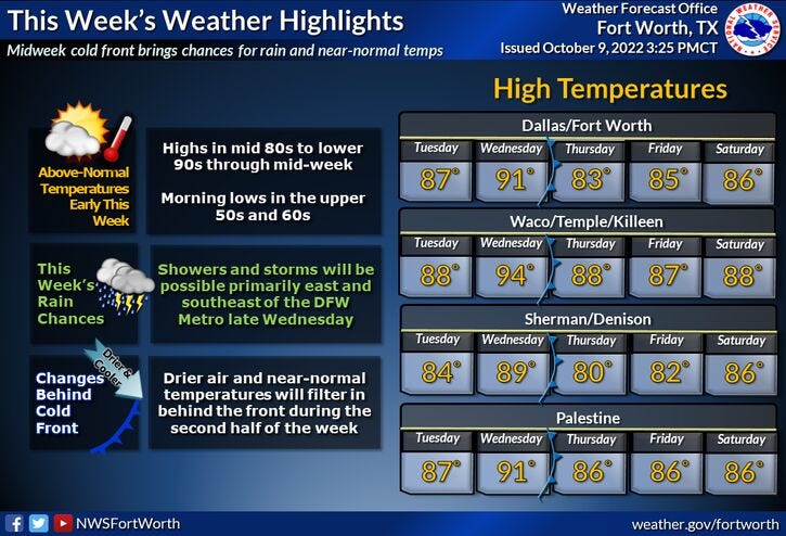
Some of you lucky ones across the Metroplex may see some showers today into tomorrow morning.. but unfortunately, most of the rain will stay just to the north and west of us. Temperatures will be above average today through Wednesday, near average on Thursday, then back above average Friday through the weekend. Our average high this time of the year is down to 81°.
Breaking your forecast down....as stated above, there will be a few showers around as the day wears on, but again, the best chances will be north and west of us. High temperatures will reach the middle 80s in DFW, a bit cooler to our northwest and a bit warmer to our southeast.
There's a slight chance of showers tomorrow morning with low temperatures in the low to mid 60s. Mostly sunny skies will dominate tomorrow with highs back in the mid 80s.. we will approach 90° on Wednesday! A weak cold front will come into the area the second half of Wednesday, but unfortunately I'm not looking for any rain along the front. There is a chance for some showers and storms east and northeast of DFW by late afternoon and evening.
Slightly cooler and drier air will filter in on Thursday with afternoon highs near 80°. South winds will rapidly return on Friday with highs back in the middle 80s. Sunny skies and middle 80s will rule on Saturday. By Sunday, some of the extended data is showing a cold front coming into the area with a chance for showers and storms. This is still 6 days away and is subject to change. I will keep you posted through the week.
That's all I've got on this fine Monday morning. Enjoy the heck out of your day and the weather when you can, it's the only weather you've got!
7-Day Headlines:
* DFW reached 82 degrees yesterday... 0.00" of rain.
* Above average temperatures.
* Slight rain chance today and early Tuesday.
* Best rain chances north and west of DFW.
* Weak (DRY) cold front Wednesday.
* A bit cooler Thursday.
* Warming into the weekend.
*Yest Rain: 0.00"; High: 82; Low: 58
*Today’s Averages: High: 81; Low: 59
*Record high: 95 (1975); Record low: 39 (1908)
*October rain: 0.00"; October deficit:
*2022 Rain: 23.42”; 2022 deficit:
*Sunrise: 7:29am; Sunset: 7:01pm
Looking Ahead:
Columbus Day: Partly cloudy and warm. Chance of showers and storms north and west of DFW. High: Low to mid 80s. Wind: SW 5-10 mph.
Tonight: Partly to mostly cloudy and mild. Slight chance of showers. Better chance north and west of DFW. Low: Low to mid 60s. Wind: South 5-10 mph.
Tomorrow: Partly cloudy, breezy and warm. Slight chance of showers through early afternoon. High: Mid 80s. Wind: South 10-20, G25 mph.
Wednesday: Partly cloudy and hot. Late day cold front. Slight chance of rain NE of DFW. High: Near 90.
Thursday: Mostly sunny and a tad cooler. High: Near 80.
Friday and Saturday: Mostly sunny and warm. Highs: Mid 80s.
Sunday: Mostly cloudy, a slight chance of showers and storms. High: Near 80.
Related

LISTEN on the Audacy App
Sign Up and Follow NewsRadio 1080 KRLD