
Some very big storms approached 35W late yesterday evening, but fell apart before they reached that point as expected. It blows my mind how much rainfall in southern Palo Pinto into county yesterday evening. The storms stalled and sat over the same area for 2 to 3 hours. This produced almost a foot of rain just north of I 20, south of Highway 180 and west of Highway 281.
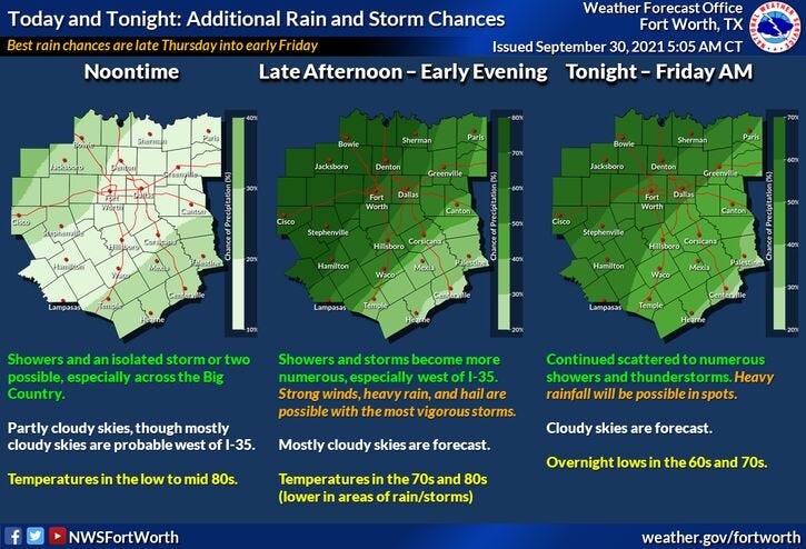
All is quiet across north Texas this morning and should remain that way through the afternoon. Widespread shower and thunderstorm activity will break out along a cold front that will stall a good 150 miles to the west of DFW by this evening. This is the area that will see a lot of rain through midnight tonight. Some of these showers and storms will edge towards the Dallas Fort Worth area this evening and then weaken overnight into Friday morning.
The front will still be to the west of us on Friday but showers and storms will form a lot closer to north Texas Friday afternoon and evening. I think our best chance of more widespread rain but we'll be between midnight Friday and noon on Saturday morning. This is when the front will start to edge our direction. By Saturday afternoon and evening, the rain will be gone and the cold front will start to slowly slide through the area. This will make for a pretty decent end to our weekend on Sunday.
Temperatures:
It's gonna be another hot one today. Afternoon highs will approach 90゚. Low eighties for Friday, near 80 for Saturday. By Sunday, skies will have cleared and dry air will slowly sneak into the area. Afternoon highs will reach the low eighties.
Similar weather with lower humidity is expected Monday and Tuesday with highs in the low eighties morning lows in the upper fifties to low sixties.
A reinforcing shot of cooler/dryer air will arrive late Tuesday, keeping our beautiful weather pattern in place next Wednesday through Friday. Morning lows will be in the fifties with daytime highs in the upper seventies to low eighties.
NOTE: I'll keep one eye open for some strong storms late this evening, mainly west of 35W and then again Friday afternoon and evening over north Texas. Wind and small hail will be the threats. There's also a flooding threat, but I think this stays West of DFW during this prolonged event.
*Yest Rain: 0.00”; *Yest High: 90; Low: 69
*Today’s Averages: High: 84; Low: 63
*Record high: 98 (1953, 1977); Record low: 43 (1984)
*September rain: 0.19”; September deficit: 2.45"
*2021 Rain: 27.03”; 2021 deficit: 0.16"
*Sunrise: 7:22am; Sunset: 7:14pm

Today: Partly cloudy and warm. Scattered late day showers and storms. High: Near 90. Wind: SSE 10-20 mph.
Tonight: Cloudy and mild. Scattered showers and storms. A few strong early to the west of 35W. Threats: Wind and small hail. Low: Near 70. Wind: SE 10-15 mph.
Tomorrow: Cloudy and a bit cooler. Scattered showers and storms. A few strong. Threats: Wind, small hail. High: Low 80s. Wind: SSE 5-10 mph.
Saturday: Mostly cloudy and mild. Scattered showers ending by early afternoon. High: Near 80.
Sunday: Partly cloudy and mild. High: Near 80.
Monday - Wednesday: Mostly sunny and nice! Lower humidity. High: Low 80s.
Related

LISTEN on the Audacy App
Sign Up and Follow NewsRadio 1080 KRLD