
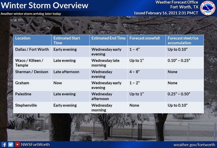
*A Winter storm warning goes into effect starting at 6:00 p.m. this evening and runs until 6:00 a.m. Thursday morning.*
TUESDAY 3PM UPDATE: Snow to our west is heading our way. Most of it stays north of Interstate 20 through the evening. Arrival time around 4:00 p.m. along Interstate 35W 5:00 p.m. along 35E.
DFW dropped to minus one at 4:48am! This is the 2nd coldest morning low ever in the month of February. The cold spot is in Gainesvile at minus 6.
Clouds will increase through the day today as the storm system starts to approach from the west. We stay precipitation free until late this afternoon into the evening. High temperatures will only warm to near 20 today, if we're lucky. It may be colder than that, if the clouds roll in quicker.
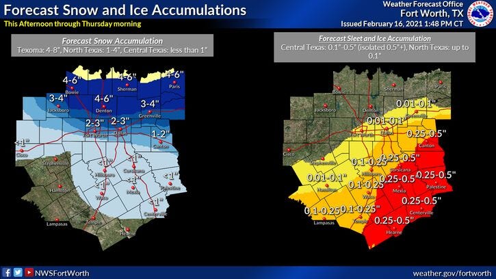
Snow should start flying, especially north of I-20 around or just before dinner time. Areas along the Red River Valley may measure 3"to 4" of snow by midnight tonight. I'm expecting maybe an inch or 2 across Dallas and Fort Worth. Another heavier area of snow and sleet will work its way in form the southwest by midnight. The heaviest precipitation will fall between midnight and 9:00 a.m. tomorrow. An additional 2" to 4" of ice and snow will fall. After 9am, light snow will continue through 6pm, with possibly another inch of accumulation. Snow and ice totals will range between 2' to 5" across the Dallas Fort Worth area with heavier totals to the north and northeast.
Temperatures will remain cold overnight tonight and into tomorrow holding steady in the low twenties.
Skies will clear from west to east on Thursday, as another reinforcing shot of cold air arrives. Sunny and windy conditions are expected with high temperatures in the middle 20s. Wind chills will be in the teens all day long.
It gets cold again Friday morning with low temperatures in the low to mid teens. High's may reach the freezing mark.
Southerly winds return into the weekend and the warm up begins. We should reach 40 by Saturday and a little above 50 by Sunday.
7-Day Headlines:
* Snow/sleet picks up towards midnight.
* Two to four inches of snow possible.
* Light snow all day tomorrow.
* Dangerous travel and continued cold through Friday.
* Thawing out this weekend!
*Winter Storm Warning 6pm today-6am Thursday*
This evening: Quiet until after 9pm. Cold! Temp: Mid to upper teens. Wind: SE 10 mph.
Tonight: Snow/some sleet.. picks up towards midnight (2”- 3”), heavier to the north of DFW. COLD! Low: Mid teens. Wind: SE 10-15 mph.
Tomorrow: Chance snow, heaviest through 9am ( 1 to 2”). Staying cold! High: Low 20s. Wind: NNW 15-15 mph.
Thursday: Morning flurries, peeks of afternoon sun. High: Mid 20s.
Friday: Sunny, continued cold. We approach the freezing mark! High: Low to mid 30s.
Weekend: Warming up and thawing out! Highs: Saturday: Near Low 40s; Sunday: Low to mid 50s!
Monday: Mostly sunny and nice! High: Mid 50s.
Tuesday: Sunny and warmer. High: Low 60s.