
The blazing heat will continue for a couple of more days, before we briefly cool off Friday through the weekend. Unfortunately, the blazing heat returns with a vengeance next week.
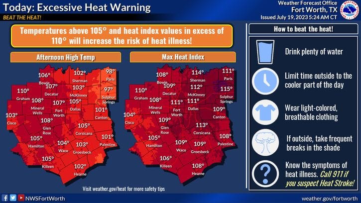
Yesterday, DFW Airport reached 108°, the hottest so far this year. And we'll approach that mark again today with some high clouds starting to move across the area. This may filter out some of the sunshine, keeping temperatures a degree or two cooler in some areas. There's a very high grass fire danger today and tomorrow, especially west of I-35W. Low humidity, lack of rainfall, and a gusty SSW wind will create this danger.
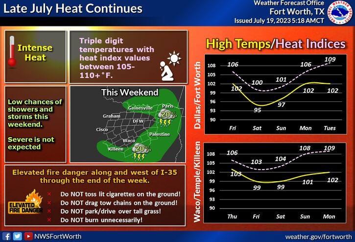
Good news: It will be slightly cooler tomorrow with a high around 104°. Only near 100° on Friday as a cold front moves through the area during the afternoon hours. Unfortunately, I don't see much rainfall along the front. This being said, there may be a few isolated showers forming overnight Friday into noon on Saturday. Coverage will only be at 10%.
FACT: The reason we're getting a rare July cold front is that this ridge of high pressure will back off to our west for a few days, allowing temperatures to only reach the low 90s on Saturday, but, we'll be back near 100 on Sunday, as the front washes out to our south. A SSW wind returns next week and so will the triple digits again. One thing in our favor next week, the humidity levels will remain low keeping our heat index values close to the ambient air temperature.
*Yest Rain: 0.00"; Yest High: 108 Low: 82
*Today’s Averages: High: 96; Low: 76
*Record high: 109 (2022): Record low: 68 (1917, 1990, 2014)
*July Rain: 0.47"; Deficit: 0.99"
*2023 Rain: 14.83"; Deficit: 6.92"
*Sunrise: 6:33am; Sunset: 8:36pm
Today: *Heat Warnings* Sunny, breezy, hot and hazy. Grass fire danger. High: 105-109. Heat index: 106-110. Wind: SSW 15-25 mph.
Tonight: Clear, breezy and warm. Low: 80-84. Wind: South 10-20 mph.
Thursday: *Heat Advisories possible* Sunny, breezy, hot and hazy. Grass fire danger. High: 102-106. Heat index: Near 105. Wind: SSW 10-20 mph.
Friday: Partly cloudy and hot. Late afternoon cold front. High: 95-100.
Saturday. Mostly to partly cloudy and cooler. An isolated shower before noon. High: Low 90s.
Sunday: Sunny, heating back up. High: Upper 90s.
Monday and Tuesday: Sunny and very hot again. Possible advisories and warnings. High: 103-107.
Related

LISTEN on the Audacy App
Tell your Smart Speaker to "PLAY 1080 KRLD"
Sign Up to receive our KRLD Insider Newsletter for more news