
4:30 PM UPDATED: The National Weather Service has issued a Red Flag Warning that will go into effect Tuesday, August 1st at 1 pm until Wednesday at 1 am for parts of North Texas.
The areas affected include Cooke, Wise, Denton, Parker, Tarrant, Hood and Johnson counties. The NWS describes a red flag warning as extreme fire weather conditions that occur due to strong winds, low relative humidity and dry vegetation. Outside burning and welding should be avoided.
Yesterday we hit 104° marking our 22nd triple digit day of the year. By next Sunday, we will have felt 29 triple digit days.
A strong ridge of high pressure will be anchored very close to North Texas through the weekend. This will create record heat in some areas. The record high for today is 106°, that's what I'm forecasting for this afternoon. The record high for Tuesday is 107°, that's what I'm forecasting for a high.
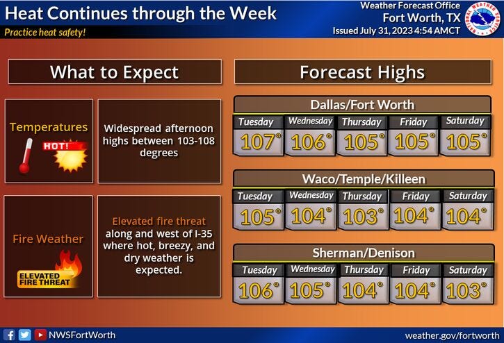
Excessive heat warnings will be in place as well, not just today and tomorrow but pretty much through the upcoming weekend. Afternoon highs will hover around 107 degrees Wednesday through Saturday, 106° on Sunday.
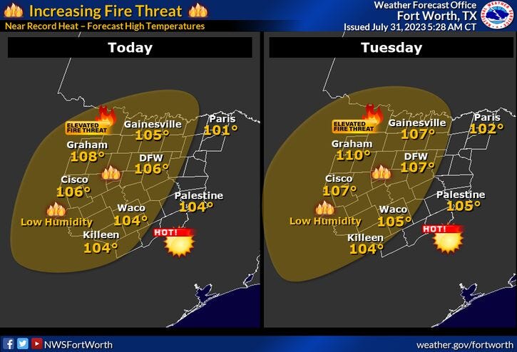
Humidity levels will remain low, but the grass fire danger will increase Wednesday through Friday, especially west of Fort Worth.
It looks like our pattern change will finally arrive late Sunday as a cold front moves into the area early Monday morning. This may increase rain chances for the first few days of next week and bring cooler temperatures to the area as well. I'll talk more about this weather change throughout the week.
*Yest Rain: 0.00"; Yest High: 104 Low: 79
*Today’s Averages: High: 97; Low: 77
*Record high: 106 (1986, 1998, 2012): Record low: 60 (1971)
*July Rain: 0.47"; Deficit: 1.55
*2023 Rain: 14.83"; Deficit: 7.48
*Sunrise: 6:41am; Sunset: 8:28pm
Today: *Excessive Heat Warning, Air Quality Alert* Mostly sunny, near record heat. Record: 106. High: 106. Grass fire danger. Wind: South 5-15 mph.
Tonight: Clear and warm. Low: 78-82. Wind: South 5-10 mph.
Tuesday: *Excessive Heat Warnings likely* Mostly sunny and hot. Near record heat. Record: 107. High: 107. Grass fire danger. Wind: South 5-15 mph.
Wednesday and Thursday: *Excessive Heat Warnings likely* Sunny, breezy, and hot. Grass fire danger. High: 107.
Friday: *Excessive Heat Warnings likely* Sunny and hot. High: 107.
Saturday: Partly cloudy and hot. High: 107.
Sunday. Partly cloudy, continued hot. Late evening cold front brings a chance of rain after midnight! High: 106.
Related

LISTEN on the Audacy App
Tell your Smart Speaker to "PLAY 1080 KRLD"
Sign Up to receive our KRLD Insider Newsletter for more news