
It's a mild and muggy start to our Monday morning...and all the storms are gone!
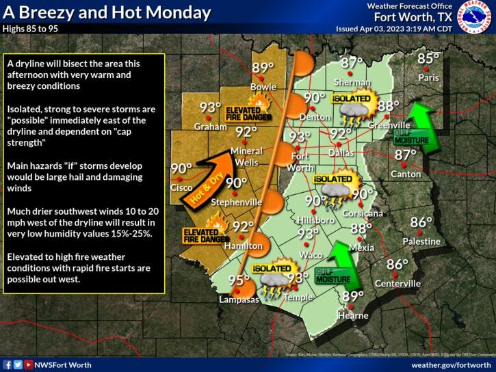
Plenty of sunshine, breezy and downright hot today with afternoon highs in the low nineties! The record high today is 95 degrees set back in 1989...There's also a very slight chance for an isolated severe storm (5pm-8pm) to break out along the dryline as it punches into north Texas. If you do see a storm in your neighborhood, Hail and wind will be the threats, but most will stay dry.
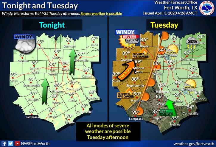
Morning clouds, afternoon sunshine will greet you on Tuesday, with lows in the mid to upper sixties, afternoon highs will reach the mid to upper eighties. A south wind will gust to 30 mph.
By late Tuesday night into Wednesday morning, a strong cold front will blow through the area. There is a chance for some severe storms just after midnight, especially east and northeast of the Dallas/Fort Worth area. I will keep you updated.
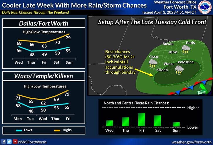
Skies will clear rapidly early Wednesday, but it will be significantly cooler and windy, with highs in the mid sixties.
Clouds increase on Thursday, with high temperatures in the mid sixties once again. By late Thursday, Friday into the 1st part of Saturday, there's a chance for rain across the area. Right now, most of the data keeps the heaviest rain south of the Dallas/Fort Worth area. I will continue to monitor the data as we approach the end of the week, and keep you updated. Afternoon highs on Friday will only reach the low sixties, near seventy for Saturday.
As it looks right now, Easter Sunday looks fantastic with plenty of sunshine. High temperatures will reach the upper seventies!
Have a terrific day, stay cool, and please enjoy the weather when you can, it's the only weather you've got!
7-Day Headlines:
* DFW reached 80 degrees yesterday. Officially, 0.60" of rain fell.
* Very warm today and tomorrow.
* Slight chance of strong storms late this afternoon/eve.
* Late night Tuesday cold front brings a chance of showers and storms.
* Much cooler Wednesday - Friday.
* Possible rain Late Thursday - Saturday.
* Easter looks Fantastic!
*Yest Rain: 0.60"; Yest High: 80 Low: 55
*Today’s Averages: High: 74; Low: 52
*Record high: 95 (1989); Record low: 30 (1987)
*April Rain: 0.60"; Surplus: 0.40"
*2023 Rain: 8.71"; Deficit:
*Sunrise: 712am; Sunset: 7:50pm
Looking Ahead:
Today: Morning clouds and patchy fog, afternoon sunshine, breezy and hot! A slight chance of a severe storm between 5pm and 9pm. Threats: Hail and wind. High: Low 90s. (Record 95 degrees). Wind: SSW 15-25 mph.
Tonight: Partly cloudy, windy and muggy. Low: Mid to upper 60s. Wind: South 15-25, G35 mph.
Tomorrow: Partly cloudy, breezy and warm. Scattered late evening storms...*towards midnight*. Some may be severe (east and NE of DFW). High: Mid to upper 80s. Wind: South 15-25, G30 mph.
Wednesday: Partly cloudy, breezy and cooler. High: Mid 60s.
Thursday: Increasing clouds and cool. Slight chance of showers by late evening. High: Mid 60s.
Friday: Cloudy and cool. Chance of rain. High: Low 60s.
Saturday. Cloudy and a tad warmer. A few leftover showers. High: Near 70.
Easter Sunday: Mostly sunny and warmer. High: Upper 70s.
Related

LISTEN on the Audacy App
Tell your Smart Speaker to "PLAY 1080 KRLD"
Sign Up to receive our KRLD Insider Newsletter for more news