
Breezy, warm and humid conditions, the threat for severe storms late tomorrow afternoon and evening, a decent weekend, slightly cooler, and then very warm to start next week off. Those are your weather highlights over the next 7 days.
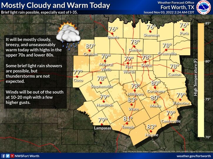
The weather will be fine today through 3:00 p.m. tomorrow across north Texas. There will be a few isolated showers between now and then, but they won't amount to much. Plenty of surface moisture and warmth will dominate our weather today through midnight tomorrow. Afternoon highs will reach the mid to upper 70s with a ton of cloud cover and some breaks in the clouds during the afternoon hours.
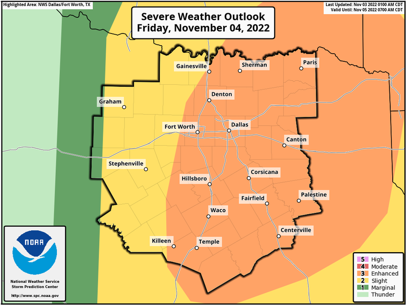
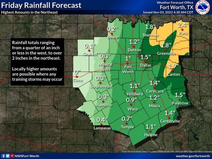
Now about the severe weather threat for north Texas. The Storm Prediction Center has put a level 3 out of 5 for severe weather, along and east of I-35W. The time frame to be weather aware will be between 3:00 p.m. and 9:00 p.m. across the immediate Dallas Fort Worth area. The later time will be Dallas and points east. All facets of severe weather are possible. The highest threat will be damaging wind, the second highest threat will be large hail and it will be very isolated, the third highest threat will be isolated tornadoes. These will be brief spinups along the leading edge of the squall line. There may be one or two warnings for tornadoes out ahead of the line if any renegade supercells form. These isolated stronger storms are the ones to watch before the line starts to get organized. After 9:00 p.m., this line of storms will really intensify as it blows into east Texas. The higher tornado threat will be east of a Greenville to Canton to Palestine line between 9:00 p.m. and midnight.
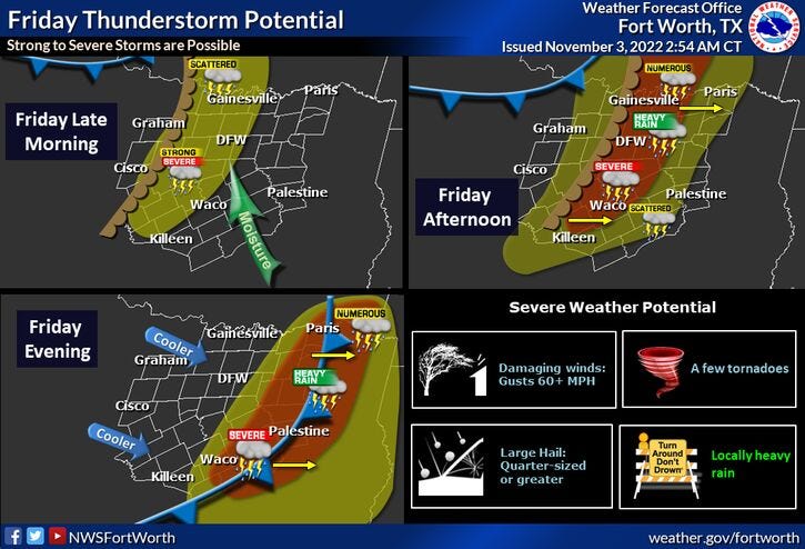
I will keep an eye on things for you as usual and have updates on NewsRadio 1080am KRLD throughout the afternoon and evening. I want to stress, this will not be a big tornado outbreak across north Texas, a little higher threat for tornadoes will be in east Texas through the Arklatex from 9pm to just after midnight.
The weekend's looking nice with drier air and lower humidity. 68 degrees for a high on Saturday, 76 degrees on Sunday and we'll be pushing 80° Monday through Wednesday of next week. Our next weather maker will be a pretty strong cold front by the end of next week, dropping temperatures to below seasonal averages.
*Yest Rain: 0.00"; High: 75; Low: 55
*Today’s Averages: High: 71; Low: 50
*Record high: 87 (1948); Record low: 25 (1991)
*November rain: 0.00"; Deficit: 0.23"
*2022 Rain: 27.85”; 2022 deficit: 4.02"
*Sunrise: 7:48am; Sunset: 6:35pm
Today: Morning clouds, a few showers...afternoon sun, with a few showers. Windy, mild and muggy. High: Mid to upper 70s. Wind: SSE 10-20 mph.
Tonight: Increasing clouds, windy, mild and muggy. Low: Upper 60s. Wind: SSE 15-25 mph.
Friday afternoon and evening: Increasing clouds, warm and windy. Late afternoon and evening showers and storms. Some severe (3pm -9pm).
Threats: Damaging wind, hail, and isolated tornadoes. High: Mid to upper 70s.
Saturday: Sunny, breezy and a bit cooler. High: Upper 60s.
Sunday: Mostly sunny, windy and seasonable. High: Mid to upper 80s.
Monday: Isolated showers and storms. High: Near 80.
Tuesday - Thursday: Mostly sunny and unseasonably warm. Highs: Near 80.
EDITORIAL: First and foremost, I want to talk about all of the non meteorologists on Facebook hyping up tomorrow's severe weather event. It's not right using scare tactics and sensationalizing to gain likes and follows.. This is not going to be a big tornado outbreak across North Texas. Could there be one or two spin-ups along the line of showers and storms? Yes.... Will there be strong tornadoes all over North texas? No.... This will mainly be a strong wind event with a few isolated spin-ups along the leading edge of a squall line as it comes through the area tomorrow evening. A different story in east Texas.. There could be a few tornadoes in the Piney Woods.
There's going to be many Storm Chasers in these areas. While this is good to gather information and ground truth, and then feed it to the weather service, some of these chasers are doing it for their own enjoyment. It's also very very dangerous to chase storms in east Texas, regardless if it's daytime or nighttime...so many TREES and it will be nighttime! If any tornadoes do drop, it will be dark in east Texas. Also, there are thousands and thousands of pine trees on two lane roads. I pray for these folks that are heading into these areas. Please be careful.
Related

LISTEN on the Audacy App
Tell your Smart Speaker to "PLAY 1080 KRLD"
Sign Up and Follow NewsRadio 1080 KRLD