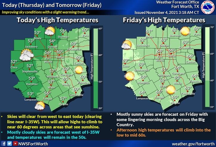

The rain is over, but the chill will stick around for a couple more days. Surface high pressure centered over St. Louis right now will continue to nose its way in from the northeast today. This will erode the cloud cover away from northeast to southwest. Don't see this very often. This being said, areas from the mid cities and points west will take longer to clear up today than areas east. This will allow temperatures to warm up into the upper fifties where the sun shines its face. Low fifties where it doesn't. This cloud cover will also play a role in tonight's overnight lows. Areas east of Dallas are in a Frost Advisory, areas west are not.

If I were you, I would go ahead and protect your plants everywhere across north Texas overnight tonight. If it clears up area wide, the Frost Advisory may be extended farther west. I'd hate for you to be caught outside with your plants down! Lol
Beautiful weather is in the forecast for tomorrow all the way through next Tuesday. Afternoon highs tomorrow will reach the mid sixties. Near 70 for Saturday. Mid 70s for Sunday through Tuesday, as suth winds pick up 15 to 25 mph bringing the higher humidity back into early next week.
Our next possible weather change will arrive on Wednesday, with a slight chance for some showers and storms along with slightly cooler temperatures.
Much cooler weather and possible rain again will arrive along a strong cold by the end of next week into the weekend.
*Yest Rain: 0.84”; *Yest High: 50; Low: 46
*Today’s Averages: High: 71; Low: 50
*Record high: 90 (2017); Record low: 25 (1991)
*November rain: 1.23”; November surplus: +0.84”
*2021 Rain: 31.28”; 2021 deficit: 0.70"
*Sunrise: 7:49am; Sunset: 6:34pm
Today: Areas of morning drizzle, then a slow decrease in clouds by afternoon. Areas west of I-35W may stay cloudy. High: 52 (west) - 59 (east). Wind: NE 5-10 mph.
Tonight: Partly cloudy and chilly. *FROST ADVISORY east of DFW*. Patchy fog. Low: 36-43. Wind: Lt. Var.
Tomorrow: Morning frost, mainly east of DFW, then mostly sunny and cool. High: Low 60s. Wind: SSE 5-10 mph.
Weekend: Sunny and perfect! Highs: Low to mid 70s. *FALL BACK SUNDAY MORNING!!*
Monday and Tuesday: More of the same. Mostly sunny and windy. High: Mid to upper 70s.
Wednesday: Partly cloudy and mild. Slight chance of showers and storms. High: Mid 70s.
Related

LISTEN on the Audacy App
Sign Up and Follow NewsRadio 1080 KRLD