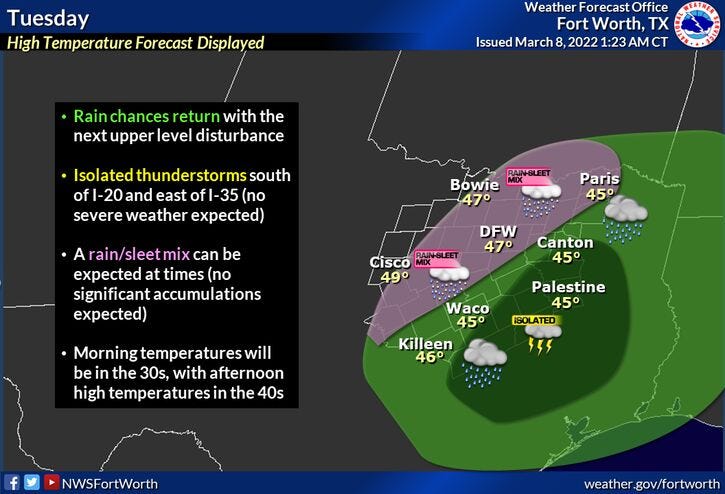

There's a lot of rain with embedded thunder to the south of the DFW area this morning. As this rapidly moves our direction by late morning into the afternoon, the heaviest rain totals will be east of the Dallas/Fort Worth area. There could be a few sleet pellets mixing in initially. Unfortunately, areas west of Fort Worth won't see much rain at all today.
With the clouds and rain around today, temperatures will not warm too much. Afternoon highs will only be in the low to mid forties. Warmest temps will be West of 35W.
Skies clear tonight and temperatures fall into the upper twenties to low thirties. There may even be some patchy fog around if the wind goes calm.
Temperatures quickly warm up tomorrow and Thursday with plenty of sunshine. We'll approach 60゚ tomorrow, upper sixties on Thursday… and then the bottom drops out late Thursday evening.
Another Arctic blast plows through the area shortly before midnight Thursday. When you wake up Friday morning, it's not out of the question that temperatures will be near freezing. To make matters worse, widespread light freezing rain, sleet, and some snow will we'll be breaking out. It's still way too early to talk about accumulations, but looking at the latest model trends precipitation totals look to be light at this time. As we all know, it doesn't take much wintry precipitation to wreak havoc on north Texas roadways.
What's different about this 3rd system to impact us here this Winter? The air won't be as cold as the last 2 events. Temperatures will most likely hover in the upper twenties to near freezing all day. Road surface temperatures will be rather warm.
It's still way too early to talk about accumulations and road impacts. I'll know a lot more by Thursday evening when I look upstream at the temperatures in the central plain states. It also depends on how deep the cold air, how dry the air will be during the onset of precipitation, and the track and strength of the upper level disturbance. Stay tuned.
A slow warm up will begin on Saturday, after a very hard freeze in the morning. Temperatures in some areas will fall into the teens. Highs Saturday will be in the mid to upper 40s. 60s by Sunday!
The critical time to watch for possible bad road conditions, especially bridges and overpasses, will be Friday morning through Saturday late morning. I'll have more as the as the week evolves.
*Yest Rain: 0.05”; *Yest High: 52; Low: 37
*Today’s Averages: High: 66; Low: 46
*Record high: 94 (1911); Record low: 22 (1996)
*February rain: 2.31”; March deficit: 0.58"
*2022 Rain: 2.31”; 2022 deficit: 3.76"
*Sunrise: 6:47am; Sunset: 6:31pm
Today: Increasing clouds and cold. Showers and isolated storms. Mixing with sleet early. Heaviest rain totals east of DFW. High: Mid 40s. Wind: ENE 10-20.
Tonight: Decreasing clouds and cold. Protect tender vegetation and pets. Low: 27-33. Wind: NE 5-10 mph.
Tomorrow: Sunny and cool. High: Near 60. Wind: Light and variable.
Thursday: Mostly sunny and warmer. High: Mid to upper 60s. Sharply colder late!
Friday: Cloudy, windy and MUCH colder. Chance of a wintry mix. High: Low 30s.
Saturday: Sunny and chilly. High: Mid to upper 40s.
Sunday: Sunny, windy, and warmer. High: Low to mid 60s.
Monday: Sunny, breezy and perfect! High: Low 70s
Related

LISTEN on the Audacy App
Sign Up and Follow NewsRadio 1080 KRLD