
We've made it through another blistering hot week. One more triple digit day today and then a brief cool down this weekend, but unfortunately the triple digits return with the vengeance all next week into the following weekend.
Friday begins in the mid 70s to low 80s. I'm also tracking a cold front that's approaching the Red River Valley. This front will move through the area this afternoon, bringing some clouds with it and a northerly wind, but unfortunately no rain along the front. There may be a few showers around tomorrow morning, but they will be few and far between.
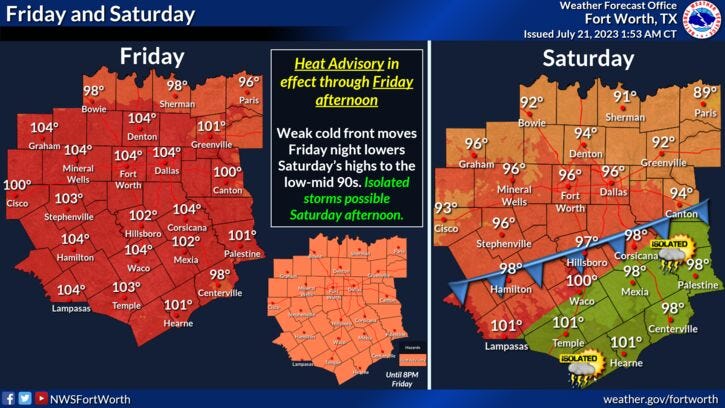
In the meantime we have another Heat Advisory in effect for today with afternoon highs near 103°. But it gets better, with the north wind in place overnight, low temperatures will drop into the upper 60s to low 70s with again some clouds and a few sprinkles around by daybreak. Clouds exit by tomorrow afternoon giving way for a beautiful day. Afternoon highs will level off in the low to mid 90s.
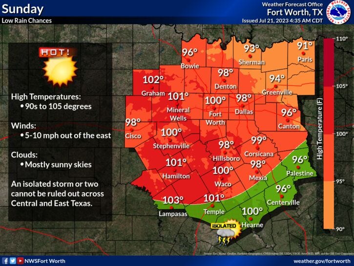
It'll be another cool start for Sunday morning with readings in the upper 60s to low 70s. Afternoon highs warm up quickly to near 100° with plenty of sunshine.
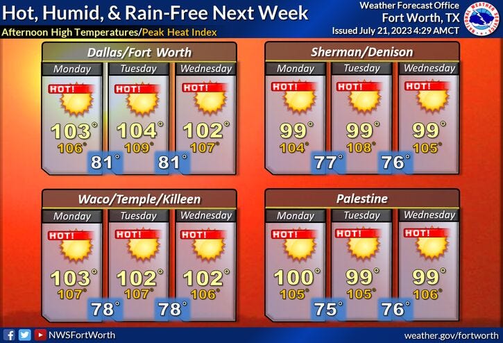
Will be shaking hands with more Heat Advisories and Excessive Heat Warnings all next week. Sunny, breezy and very hot with afternoon highs ranging between 103° and 106°. No rain is in the forecast as this next high pressure system means business.
*Yest Rain: 0.00"; Yest High: 104 Low: 83
*Today’s Averages: High: 96; Low: 76
*Record high: 109 (2018): Record low: 66 (1989)
*July Rain: 0.47"; Deficit: 1.09"
*2023 Rain: 14.83"; Deficit: 7.02"
*Sunrise: 6:35am; Sunset: 8:34pm
Today: *Heat Advisory* Partly cloudy and hot. Late afternoon cold front, no rain expected. High: 103, cooler towards the Red River. Heat index: 105-107. Wind: Shifting north 10-20 mph.
Tonight: Mostly cloudy and cooler. A few sprinkles towards daybreak. Low: 67-73. Wind: NNE 10-20 mph.
Saturday: Morning sprinkles, afternoon sun. COOLER! High: Low to mid 90s. Wind: NNE 10 mph.
Sunday: Sunny, heating back up. High: Near 100.
Monday - Thursday: Sunny, breezy and very hot. High grass fire danger west of I-35W. Possible advisories and warnings return. Highs: 103-106.
Related

LISTEN on the Audacy App
Tell your Smart Speaker to "PLAY 1080 KRLD"
Sign Up to receive our KRLD Insider Newsletter for more news