
The heat builds back across north Texas through the weekend, but a bit of a break from the intense heat arrives by early next week. Plus, a few lucky Texans we'll see some rain.
43 triple digit temperatures so far this year and counting. We will add five more days to that total by next Monday. This will exceed the number of triple digit days we felt last year. Plus, records may be tied or broken today through Sunday as well. It'll all come to an end soon. Fall is just 30 days away.
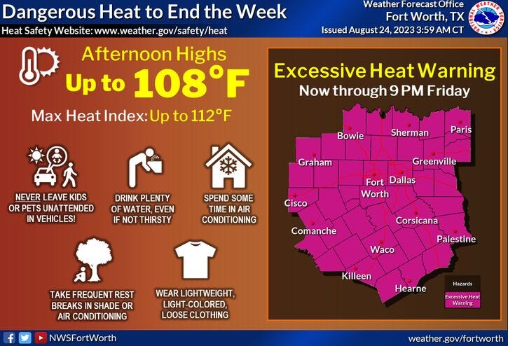
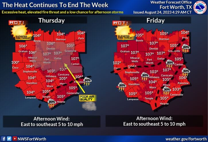
An Excessive Heat Warning is in place today and tomorrow. These will most likely be extended into the weekend as well. I'm forecasting a high of 106 today, 108 tomorrow, 107 on Saturday, and 106 on Sunday. These readings will tie or break records each day.
If you're lucky, you may see a nice late day storm southeast of the area on Saturday. 20% coverage on Sunday, 30% coverage on Monday, and a 30% coverage on Tuesday (south of DFW). What's causing this weather change you ask? A weak cold front. This front will slide through the area on Monday, increasing our rain chances for the first time in weeks. Plus, we all get to see what clouds look like again.
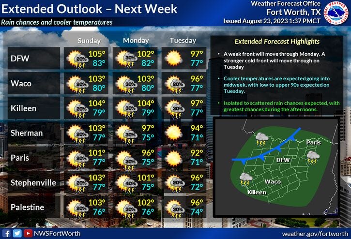
With more clouds in the area and rain on radar, the high on Monday will be 101°, 95 for Tuesday, and 98 for Wednesday. Unfortunately, the triple digits will return by the end of next week. Good news: We may not feel 105° + temperatures again in 2023... time will tell.
*Yest Rain: 0.00"; Yest High: 103; Low: 83
*Today’s Averages: High: 95; Low: 75
*Record high: 106 (2011): Record low: 60 (1961)
*August rain: Trace; Deficit: 1.48
*2023 Rain: 14.83"; Deficit: 9.02
*Sunrise: 6:57am; Sunset: 8:03pm
Today: *Execessive Heat Warning* Mostly sunny and hot. High: 106 (Record is 106). Heat index near 110. Wind: East 5-10 mph.
Tonight: Clear and warm. Low: 78-83. Wind: East 5-10 mph.
Friday: * Excessive Heat Warning* Mostly sunny and hot. Record heat. High: 108 (Record is 106. Wind: Variable 5-10 mph.
Saturday: *Possible Excessive Heat Warnings* Partly cloudy and hot. Isolated late day storms SE of DFW. Record heat. High: 108 (Record is 106).
Sunday: Partly cloudy, continued hot. Cold front approaches by late evening. Slight chance of rain late. High: 106 (Record is 107).
Monday: Partly cloudy, not as hot. Scattered showers and storms. 30% coverage. High: 101.
Tuesday: Partly cloudy and warm. Scattered showers and storms. Best chance south of I-20. High: Mid 90s.
Wednesday: Mostly sunny and warm. High: Upper 90s.
Related

LISTEN on the Audacy App
Tell your Smart Speaker to "PLAY 1080 KRLD"
Sign Up to receive our KRLD Insider Newsletter for more news
Follow us on Facebook | Twitter | Instagram | YouTube