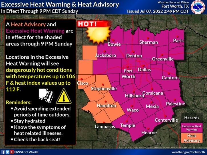

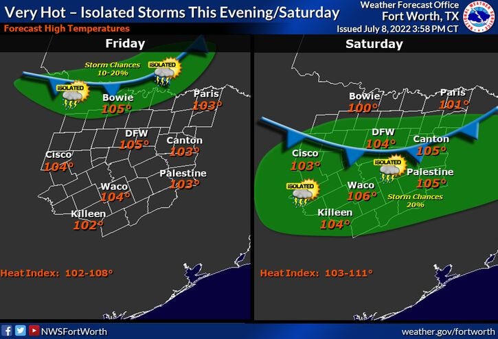
Excessive Heat Warnings are in effect for most of north Texas through Sunday evening. Afternoon highs will range between 103 and 105 today and tomorrow... 102 for Sunday. Heat index values will range between 106 and 110.
A few of you lucky ones may see some scattered showers and storms this evening along the Red River Valley. Another chance for scattered storms just about anywhere across north Texas tomorrow, but coverage will only be 20%.
The heat will continue into early next week with high temperatures around 103 on Monday and Tuesday. By Wednesday, a cold front will creep through the area, increasing rain chances and knocking temperatures down into the 90s.
Unfortunately, the rain chances will be brief... we dry out Thursday with high temperatures in the upper 90s. As of now, it looks like the triple digit heat will return by the end of next week into the weekend.
*Yest Rain: 0.00”; *Yest High: 103; Low: 82
*Today’s Averages: High: 95; Low: 75
*Record high: 107 (1956); Record low: 62 (1952)
* July rain: 0.00”; July deficit: 0.69"
*2022 rain: 12.41”; 2022 deficit: 8.57"
* Sunrise: 6:27am; Sunset: 8:40pm
Today: *Excessive Heat Warning* Sunny and hot. High: 104. Heat index 107. Wind: SSW 5-10 mph.
Tonight: Slight chance of storms near The Red River early, otherwise clear and warm. Low: Low 80s. Wind: SSW 5-10 mph.
Tomorrow: *Excessive Heat Warning* Partly cloudy, hot and humid. Isolated afternoon and evening showers and storms. High: 105. Heat index near 110. Wind: SE 5-10 mph.
Sunday: *Excessive Heat Warning* Partly cloudy, continued hot. High: 103.
Monday: Sunny and hot. High: 103.
Tuesday: Partly cloudy and continued hot. Slight chance of showers and storms late. High: 103.
Wednesday: Mostly cloudy and cooler. Chance of showers and storms. High: Low to mid 90s.
Thursday: Mostly sunny and hot. High: Mid to upper 90s.
Related

LISTEN on the Audacy App
Sign Up and Follow NewsRadio 1080 KRLD