
The National Weather Service issued Severe Thunderstorm Warnings for parts of Dallas, Denton, and Ellis counties Wednesday afternoon, with a chance of rain in the forecast for later in the day.
The primary threats associated with the storms are strong winds and hail up to the size of a quarter.
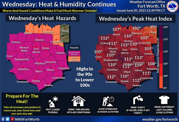
Wednesday started with temperatures in the low 80s with a heat index value of 97 degrees at DFW Airport. The day will be mostly sunny, hot, hazy, and humid today with afternoon highs in the upper 90s. Heat indices will be above 110 degrees during the afternoon hours.
This evening, thunderstorms could form in the eastern Panhandle and head towards North Texas toward midnight. If the cap breaks over Dallas-Fort Worth, these storms will make it through North Texas, producing welcome rain. The threats will be small hail and damaging wind. The chances of this happening are at 30%. The highest chance of rain will be west and northwest of DFW.
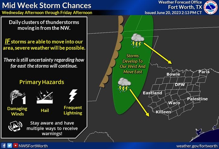
Morning clouds and afternoon sunshine for Thursday with afternoon highs "only" in the low to mid-90s. All eyes will shift to our northwest again late Thursday night into Friday morning, as another complex of storms tries to make it into North Texas. Once again, it'll depend on our cap strength.
Near-average temperatures on Friday with afternoon highs near 90 degrees. Once again, I'll be keeping my eyes to our northwest for possible late evening storms.
Unfortunately, our storm chances vanish this weekend into the middle of next week, as this bubble of high pressure in the upper levels of the atmosphere returns to North Texas. This means temperatures will approach the triple digits early next week, heat indices will exceed 110 degrees and Excessive Heat Warnings will likely return.
*Yest Rain: 0.00"; Yest High: 98; Low: 81
*Today’s Averages: High: 923 Low: 73
*Record high: 107 (1936): Record low: 58 (1976)
*June Rain: 0.63"; Deficit: 1.91"
*2023 Rain: 14.21"; Deficit: 4.92"
*Sunrise: 6:20am; Sunset: 8:40pm
Wednesday: *Excessive Heat Warning* Summer arrives at 9:58am. Mostly sunny, hazy, humid and hot. High: Upper 90s. Heat index: 110-116. Wind: SE 10-20 mph.
Wednesday night: Increasing clouds. 30% coverage of strong and isolated severe storms towards midnight. Best chance NW and west of DFW. Threats. Damaging wind, moderate size hail. Low: Mid to upper 70s. Wind: SE 10-20 mph.
Thursday: Morning clouds, afternoon sun. Hazy, humid and hot. A slight storm chance after midnight. High: Low 90s. Heat index: Near 105 degrees. Wind: East 10-15 mph.
Friday: Morning showers and storms, then slow clearing. Cooler! A slight evening storm chance west of I-35W. High: Near 90.
Weekend: Mostly sunny, hot and humid. Highs: Mid to upper 90s.
Monday and Tuesday: Mostly sunny, hot and humid. High: Near 100.
Related

LISTEN on the Audacy App
Tell your Smart Speaker to "PLAY 1080 KRLD"
Sign Up to receive our KRLD Insider Newsletter for more news