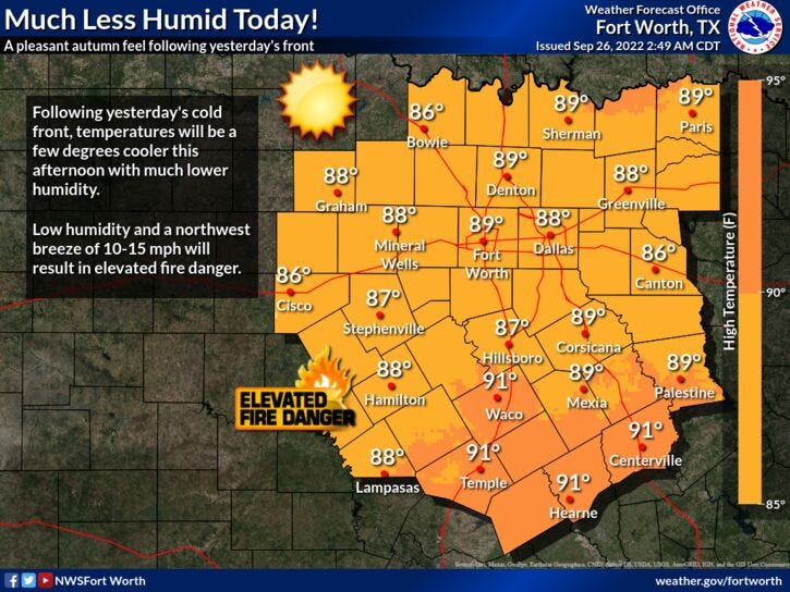

Cooler temperatures, much lower humidity, plenty of sunshine, and no rain. Those are our weather stories for the next seven days.
The cold front that moved through the area yesterday afternoon and evening is now well to the south of north Texas. It did produce a couple of storm warnings for wind yesterday. Some sporadic damage was reported in southern Collin and Dallas counties. There were also numerous power outages in these areas. Unfortunately, not a drop of rain fell at DFW Airport.
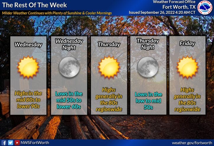
We're waking up to temperatures in the 60s this morning! There's even some upper 50s north and NW of DFW. Plus, you'll definitely notice the lower relative humidity. This dry air will continue to dominate our weather all week long. We'll enjoy nice cool mornings and warm afternoons. Morning low's will be in the 50s and 60s with afternoon highs in the 80s. By this weekend, some areas may hit 90° , especially on Sunday. The State Fair of Texas opens on Friday! Morning lows will be in the 50s with afternoon highs in the middle 80s.
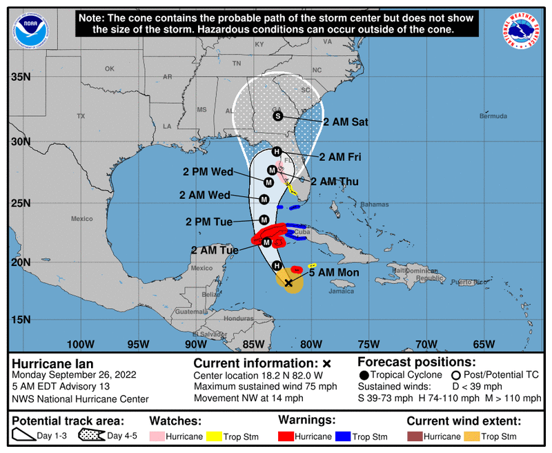
Shifting gears to the tropics, Ian is now a hurricane as of 4:00am this morning. Wind is at 75 mph and it's moving NW at 14 mph. It's located about 85 miles southwest of Grand Cayman Island. Unfortunately, rapid strengthening is forecast over the next few days. Residents from western Cuba to the Gulf-side of Florida need to start making preparations now. This storm is forecast to become a major hurricane in the next 24 to 36 hours. Also, Ian poses no threat to Texas.
Enjoy the cooler temperatures, lower humidity, and the weather, when you can, it's the only weather you got!
7-Day Headlines:
* DFW hit 98 degrees yesterday... 0.00" of rain.
* 12 hours of daylight/12 hours of darkness today!
* Monitoring Ian as it enters the eastern Gulf on Wednesday.
* Landfall Thursday or Friday somewhere in Florida.
* Cool mornings and warm afternoons this week.
* No rain for a while.
* Near 90 this weekend.
*Yest Rain: 0.00"; High: 98; Low: 75
*Today’s Averages: High: 86; Low: 65
*Record high: 100 (1977); Record low: 45 (1912, 1942)
*September rain: 0.33"; September deficit:
*2022 Rain: 23.42”; 2022 deficit:
*Sunrise: 7:19; Sunset: 7:19am
The Week Ahead
Today: Sunny and cooler. Low humidity. High: Mid to upper 80s. Wind: NNE 10-20 mph.
Tonight: Clear and cool. Lows: 58-64. Wind: NE 5 mph.
Tomorrow: Sunny and warm. Low humidity. High: Mid to upper 80s. Wind: ESE 5 mph.
Wednesday and Thursday: A cool start (60's), then sunny and warm. High: Mid 80s.
Friday-Sunday: Sunny and warm. Highs: Upper 80s.
Related

LISTEN on the Audacy App
Sign Up and Follow NewsRadio 1080 KRLD