
We're waking up to temperatures a little cooler than what we have been experiencing over the past several days. We can thank the dryer air that's in place at this hour.
Unfortunately, we hit a hundred degrees yesterday, but dryer air heats up faster, but it also cools off quicker. That explains the comfortable feel to the air this morning. Temperatures are in the upper 60s to mid-70s. Enjoy!
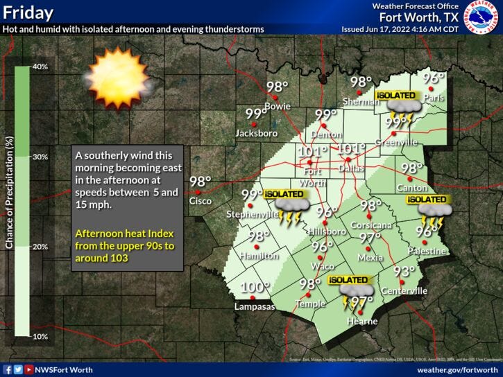
Unfortunately, the humidity will increase this afternoon and will stick around until tomorrow as well, as a bubble of increased humidity moves in from the east. It's called an Easterly Wave. This being said, there's a slight chance for an isolated shower or storm anywhere across north Texas by early evening. Best chances will be late this afternoon to the east of Dallas. Afternoon highs today will still creep up into the upper 90s. Stay cool!
Father's Day weekend is looking hot and a bit humid. One more chance of an isolated late day shower or storm tomorrow anywhere across north Texas and then the rain chances shut off for Father's Day. We'll reach the middle 90s tomorrow, upper 90s for Father's Day with heat index values around 102 each day.
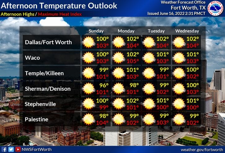
Unfortunately, that upper level ridge of high pressure that's been to our east this past week will creep our direction next week, shutting off rain chances and causing those temperatures to warm! Daytime highs on Monday and Tuesday will be near 100 degrees, 102 to 104 for Wednesday and Thursday. Also, we won't be dealing with extraordinary high heat index values because the air will dry out once again.
That's all I've got on this comfortable Friday morning! Have a great Father's Day weekend and enjoy the weather when you can, it's the only weather you've got!
____________________________________________________
7-Day Headlines:
* Yesterday’s high at DFW: 100 degrees.
* Four 100 degree days so far this year.
* Slight rain chance today and tomorrow.
* No Heat Advisories, for now.
* Saharan dust through the weekend.
* Above average temperatures continue through next week.
* Summer arrives in 4 days.
_________________________________________________________
*Yest Rain: 0.00”; *Yest High: 100; Low: 81
*Today’s Averages: High: 92; Low: 73
*Record high: 105 (1911); Record low: 58 (1981)
_________________________________________________________
* June rain: 2.64”; June surplus: +0.59”
*2022 rain: 12.41”; 2022 deficit ”>
*Sunrise: 6:20am; Sunset: 8:39pm
Today: *Air Quality Alert* Partly cloudy, hot, hazy and humid. Slight chance of an afternoon and evening shower or storm! High: Upper 90s. Heat index 103. Wind: ESE 10-20 mph.
Tonight: Mostly clear. Low: 75-80. Wind: SSE 10-20 mph.
Tomorrow: Partly cloudy, hazy, hot and humid. Isolated late day shower or storm. High: Mid 90s. Heat index 103. Wind: ESE 10-20 mph.
Fathers Day: Mostly sunny , continued hot. High: Upper 90s.
Monday - Thursday: Sunny, breezy and hot. Highs: 99--103.
Related

LISTEN on the Audacy App
Sign Up and Follow NewsRadio 1080 KRLD