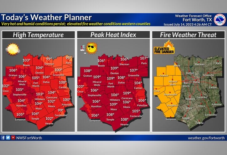

The Excessive Heat Warnings have been downgraded to Heat Advisories. These advisories are in place both today and tomorrow across all of north Texas. Heat index values will range between 105° and 109° but some areas may experience 110+. The afternoon high will reach 103°, tomorrow 101°. The average high this time of the year is 95°.
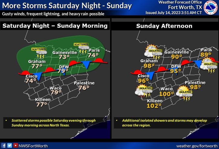
A few isolated showers will dot the area Saturday morning, a slightly better chance, 30% coverage, will move into the area late Saturday evening through Sunday afternoon as a cold front stalls across the area. This will keep temperatures down into the mid to upper 90s on Sunday. Any storms that do form have the chance to become severe with damaging wind being the primary threat. Please keep in mind 70% of you won't see a drop. After Sunday, the brutal heat returns with a vengeance all next week.
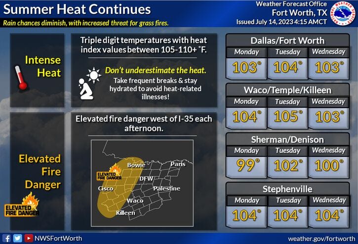
Afternoon highs Monday through Thursday will range between 102° to 108°, with the hottest temperatures Fort Worth -> west. Heat index values will be close to 110 so possible Heat Warnings may return, Heat Advisories for sure.
Also, due to a gusty southwesterly wind, a high grass fire danger returns (west of Fort Worth) all next week as well. Please be smart.
*Yest Rain: Trace; Yest High: 104: Low: 81
*Today’s Averages: High: 95; Low: 76
*Record high: 107 (1925, 1980): Record low: 62 (1990)
*July Rain: 0.15"; Deficit: 0.98
*2023 Rain: 14.51"; Deficit: 6.91
*Sunrise: 6:30am; Sunset: 8:38pm
Friday: *Heat Advisory* A few morning sprinkles, then mostly sunny, breezy, hot, and humid. High: 101-105. Heat index: Approaches 110 degrees. Wind: South 10-20 mph.
Friday night: Partly cloudy, breezy, muggy and warm. A few overnight showers (northwest). Low: 78-82. Wind: South 15-25 mph.
Saturday: *Heat Advisory* A few morning showers and isolated storms, then partly cloudy, hot, and humid. Scattered storms towards midnight. High: 97-102. Heat index: Approaches 110 degrees. Wind: SSW 10-20 mph.
Sunday: Morning showers and storms, then partly cloudy and a tad cooler. A slight chance of afternoon and evening storms. High: Mid to upper 90s.
Monday-Thursday: Heat Warnings and advisories return. Mostly sunny, heating up again. Breezy and hot. Highs: 102-108. Heat indicies approach 110 degrees.
Related

LISTEN on the Audacy App
Tell your Smart Speaker to "PLAY 1080 KRLD"
Sign Up to receive our KRLD Insider Newsletter for more news