
The National Weather Service has issued a Severe Thunderstorm Watch for parts of North Texas, including Collin, Denton, and Rockwell counties until 4 a.m. Friday. An earlier Tornado Watch that covered most of North Texas was allowed to expire at 10 p.m.
Earlier Thursday, the dewpoint reached 80 degrees at DFW Airport, which tied the record high. That equated to a heat index of 108 degrees around 3 p.m.
The atmosphere was "juiced" on Thursday morning, meaning it was primed and ready for severe weather. The primary threats would be large hail, damaging winds, and isolated tornadoes.
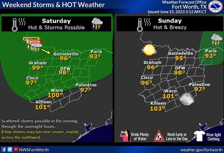
It's not even summer yet and we'll be flirting with triple-digit heat through the weekend and into next week. Plus, we've got more storms in the forecast, scattered, but be weather aware. Severe storms are possible again Saturday late evening across much of North Texas.
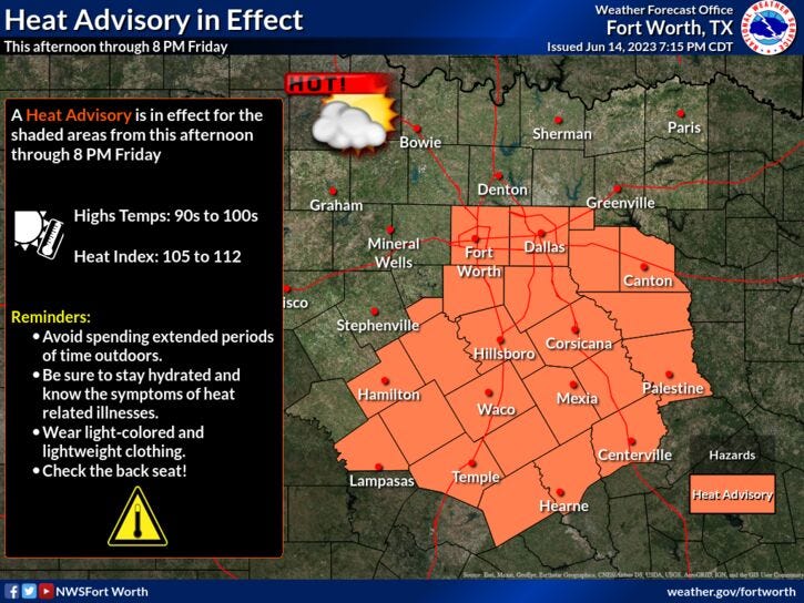
Our first heat advisory of 2023 was posted for DFW and points south on Thursday. I'm sure none of you are standing and applauding right now. The feels-like temperature will approach 105 degrees Thursday, Friday and through the weekend. Plus, we have the risk of severe storms, especially north of Highway 380 this evening. Large hail will be the threat. Afternoon highs will reach the mid-90s.
Friday will be mainly dry with highs in the upper 90s. Heat index values could be as high as 105 degrees.
This weekend will be partly cloudy, hot, hazy, and humid. Afternoon highs will be near one hundred degrees. Heat index values 105 to 107゚. There's also a chance for some severe storms late Saturday, but most will stay dry. Hail will be the main threat.
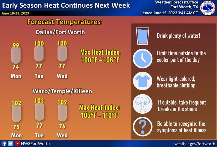
Next week will be partly cloudy, hot, hazy, and humid, with afternoon highs near 100°. Plus, with a northerly flow in the upper levels of the atmosphere, there is a chance for some overnight storms Wednesday and Thursday mornings. Still days away, but will be monitored.
*Yest Rain: 0.00"; Yest High: 91; Low: 74
*Today’s Averages: High: 92; Low: 72
*Record high: 105 (1924): Record low: 59 (1903, 1933)
*June Rain: 0.63"; Deficit: 1.18"
*2023 Rain: 14.21"; Deficit: 4.19"
*Sunrise: 6:19am; Sunset: 8:38pm
Today: * Heat Advisory* (DFW -> south)...Partly cloudy, hazy and hot. Scattered strong and severe storms by evening. Threat: Large hail. High: Mid to upper 90s. Heat index: 105 degrees. Wind: SSE 10-20 mph.
Tonight: Scattered evening severe storms. Threat: Large hail, then partly cloudy and very humid. Low: 70-75. Wind: ESE 10-20 mph.
Tomorrow: *Heat Advisory* Partly cloudy, hot and humid. High: Upper 90s. Heat index 105 degrees. Wind: North 5-10 mph.
Weekend: Partly cloudy, hot and hazy.Mostly sunny, hot and humid. Possible Heat Advisory. Scattered severe storms by evening. Highs: Upper 90s. Heat index near 105.
Monday - Wednesday: Mostly sunny, hot and humid. Possible Heat Advisory. Slight storm threat late Tuesday and Wednesday. Highs: 99-102. Heat index 105+.
Related

LISTEN on the Audacy App
Tell your Smart Speaker to "PLAY 1080 KRLD"
Sign Up to receive our KRLD Insider Newsletter for more news