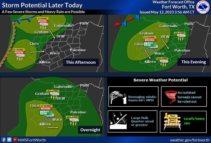

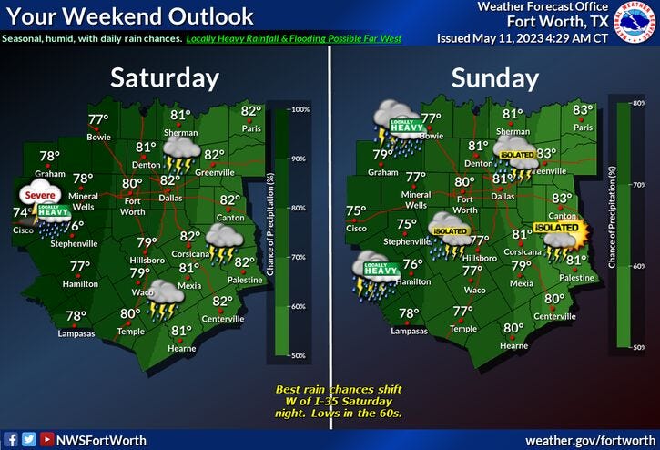
We're OK for most of today, with just a few showers dotting the area late this morning through the afternoon. By late this evening a large area of showers and storms, some severe (hail and wind), will move in from the west and NW, a brief break in the storms the first half Saturday, then more storms, some severe, develop by late Saturday afternoon and evening.
Any of these storms may be coming severe (hail and wind). Another wave of showers and storms will develop during the day on Mother's Day. Some rain could be heavy at times, and yes, another wave of showers and storms possible on Monday. It's still way too early to tell if these will be severe.
Some data suggests we may have a cold front slide through the area late Monday pressing most of the rain south of us Tuesday through Thursday, but I'm keeping isolated showers and storms in the forecast, especially during the afternoon and evening hours each day.
Rainfall totals over the next 7 days, hard to gauge.. Depends on the track of the upper level disturbances that's a cruise across the area over the next seven days. If I were to make an educated guess...2"-4" of rain is not out of the question for DFW, but isolated higher totals are possible, especially west of DFW....lighter totals to the east of us.
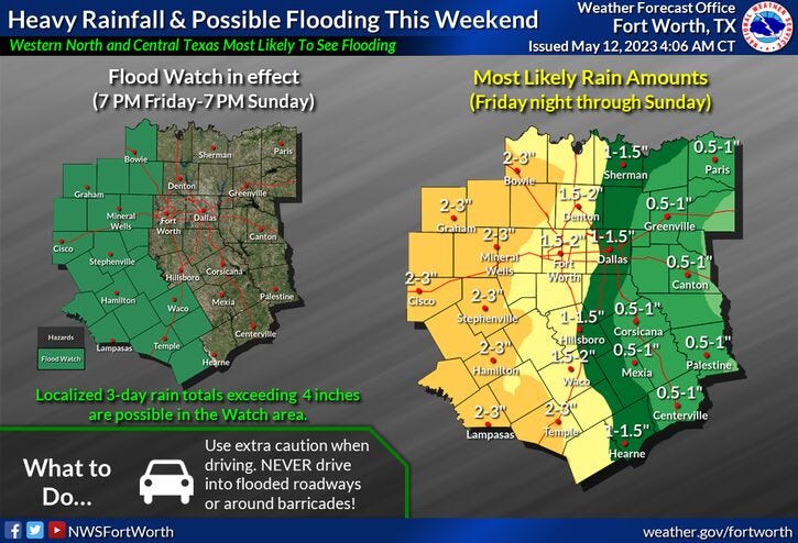
All this being said, a Flood Watch goes into effect at 7pm this evening through Sunday at 7 PM for areas just west of DFW. This Watch MAY be extended farther east, depending on radar trends.
Temperatures: Our warmest day will be today with highs in the upper eighties, cooling into the seventies while it's raining, Low eighties if you see any sunshine through Monday. By Thursday, we'll be back in the mid eighties.
*Yest Rain: 0.01"; Yest High: 88; Low: 65
*Today’s Averages: High: 82; Low: 63
*Record high: 98 (1978): Record low: 44 (1960)
*May Rain: 0.63"; Deficit: 1.02"
*2023 Rain: 11.86"; Deficit: 1.60"
*Sunrise: 6:31am; Sunset: 8:18pm
Today: Morning cloudy, afternoon sun. A few showers and isolated storms. Breezy, warm and humid. High: Mid to upper 80s. Wind: South 10-20 mph.
Tonight: *Flood Watch starts at 7pm (west of DFW)* Cloudy and muggy. Showers and storms moving in toward late evening. Some storms may become severe. Rain may be heavy at times. Low: Low 70s. Wind: South 10-20 mph.
Tomorrow: *Flood Watch (west of DFW)* Numerous showers and storms, some severe. Rain may be heavy at times. Flooding concern, especially west of I-35W. High: Upper 70s.
Mother's Day: *Flood Watch (west of DFW)*Mostly cloudy. Scattered showers and storms. High: Near 80.
Monday and Tuesday: Mostly to partly cloudy. Scattered showers and storms. Highs: 75-82.
Wednesday and Thursday: Mostly to partly cloudy. Isolated showers and storms. Highs: Low to mid 80s.
Related

LISTEN on the Audacy App
Tell your Smart Speaker to “PLAY 1080 KRLD”
Sign Up and Follow NewsRadio 1080 KRLD
Facebook | Twitter | Instagram