
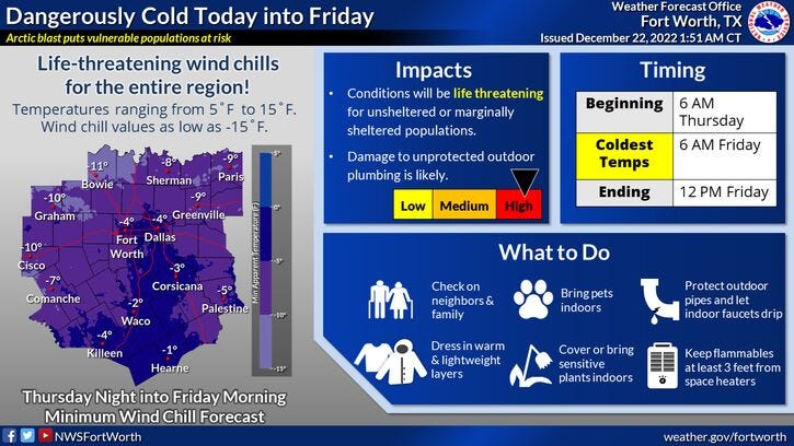
Life-threatening wind chills set in Thursday across North Texas
Very cold Siberian air, a heck of a lot of wind, dangerous wind chills, a few snow flurries, 72 hours of sub freezing temperatures, and a rapid warm up next week. Those are your weather stories over the next 7 days.
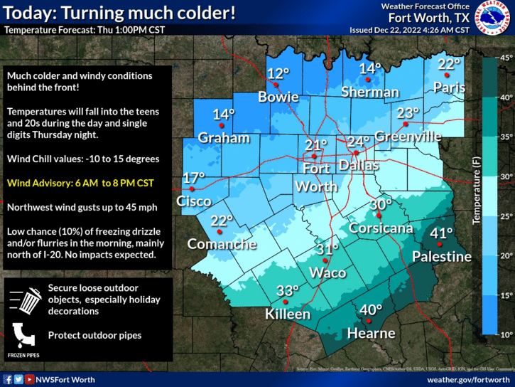
We're waking up to temperatures in the low 40s with a little bit of fog with an overcast sky.The bitter cold air is rapidly heading towards north Texas at this hour. It will be arriving from NW to SE between 7:00 a.m. and 9:00 a.m. It will arrive in DFW close to 8:00 a.m. Temperatures will fall from the low 40s into the low twenties within an hour or two. Wind will gust as high as 45 mph for a few hours behind the front; gusts over 35 mph through the rest of the day.
Temperatures will be in the teens after the noon hour and settle into the single digits and low teens by tomorrow morning. Wind chills will be near zero this afternoon and range anywhere between -5 and -15 tomorrow morning. Therefore we have a Wind Chill Advisory in effect from 6:00 a.m. this morning until noon tomorrow. We also have a Hard Freeze Warning in effect tonight, as temperatures dip between 5 and 10°.
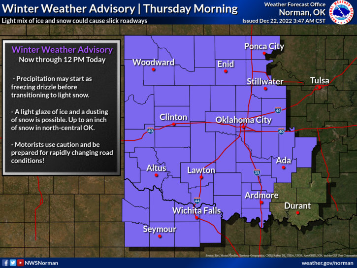
Also, don't be surprised if you see some snow flurries through the early afternoon hours today, but no accumulations are expected.
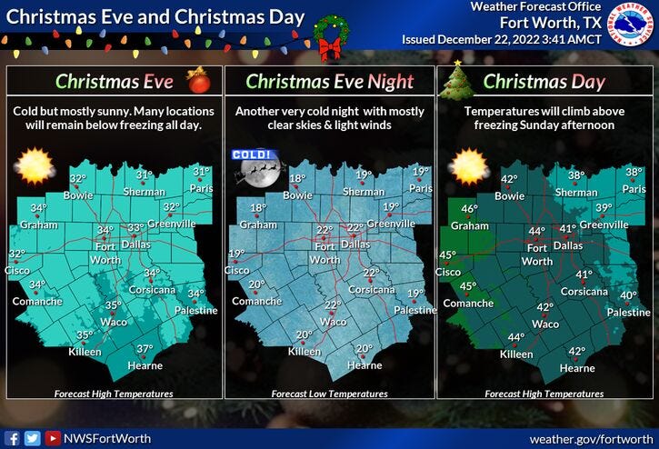
We stay below freezing tomorrow through noon Christmas Day. Afternoon highs tomorrow will only reach the low 20s. We're back in the teens on Saturday morning with a high near 30°. Near 20° for Christmas morning, close to 40° by afternoon.
Our warm up continues into next week, with afternoon highs getting back into the 50s Monday and Tuesday, approaching 60° by Wednesday!
**Important: Please remember to drip your faucets and open your cabinet doors from 9:00 a.m. this morning until noon on Christmas Day. Also if it's not too late, secure or bring in your outdoor holiday decorations.
Stay warm my friends and enjoy the weather when you can, it's the only weather you've got!
7-Day Headlines:
* DFW reached 52 degrees yesterday.
* Cold blast in north Texas this morning.
* Wind Chill Adv., Hard Freeze Warning, Wind Adv.
* 40s early, Near 20 by noon, teens this evening.
* Snow flurries through afternoon. No accumulations.
* Below zero wind chills into Friday morning.
* 72 hours of sub-freezing temperatures. Warming next week.
*Yest Rain: 0.00"; High: 52; Low: 31
*Today’s Averages: High: 57; Low: 37
*Record high: 81 (1964); Record low: 3 (1989)
*December rain: 2.38"; Surplus: 0.47"
*2022 Rain: 36.63”; 2022 Surplus 0.55"
*Sunrise: 7:27am; Sunset: 5:26pm
Looking Ahead:
Today: **Wind Chill Adv./Wind Adv. Morning fog. Cold front arrives mid morning. Turning sharply colder. Snow flurries possible. Temps: Noon: 15-20 degrees; 6pm: 13-18 degrees. Wind chills: Zero to 5 degrees. Wind: NNW 20-30, G40 mph.
Tonight: ** Hard Freeze Warning/ Wind Chill Advisory**. Clear, windy and VERY Cold. Low: 8-12, wind chills -5 to -15. Wind: NNW 15-25, G30 mph.
Tomorrow: ** Wind chill advisory until noon**. Partly cloudy, windy and cold. High: Low to mid 20. Wind chills in the teens. Wind: NNW 15-25 mph.
Saturday: Partly sunny, continued cold. Less wind. Low: 15-20; High: Low 30s.
Christmas Day: Mostly sunny and a bit warmer. Low: 18-22; High: Near 40.
Monday: Sunny with a continued warm up. High: Low 50s.
Tuesday: Sunny and cool. High: Mid to upper 50s.
Wednesday: Sunny. Our warm up continues! High: Near 60.
Related

LISTEN on the Audacy App
Tell your Smart Speaker to "PLAY 1080 KRLD"
Sign Up and Follow NewsRadio 1080 KRLD