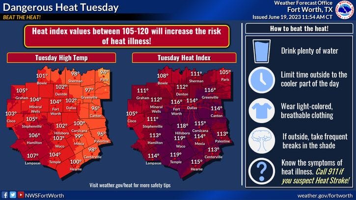

Excessive heat warnings are in place today and tomorrow across all of north Texas. This means the heat index values will range between 110 and 120 degrees during peak heating hours. Temperatures will be near one hundred degrees today, upper nineties tomorrow.
Due to more clouds in the area on Thursday and Friday, and the upper level ridge briefly sliding off to the west, this will help keep the temperatures down a bit. Forecasting afternoon highs in the low to mid 90s on Thursday, near 90 on Friday.
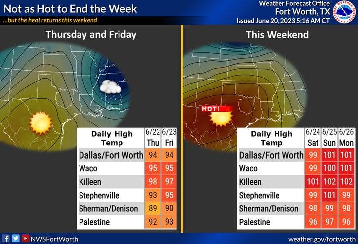
But unfortunately, temperatures rebound back into the upper 90s on Saturday, near 100 degrees on Sunday. If we're lucky, another weak cold front will back into the area on Monday, knocking temperatures back into the mid 90s.
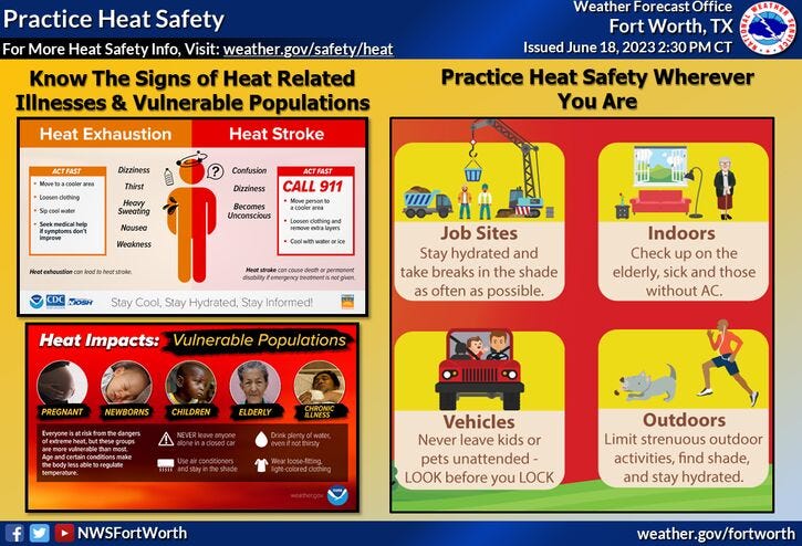
Please remember your beat the heat precautions; spend very little time outdoors, drink plenty of water, and please check on the pets, elderly and homeless.
Also, we do have Tropical Storm Brett that has formed well to the east of the Lesser Antilles. Further strengthening to a Cat 1 hurricane is possible as it enters the eastern Caribbean this weekend. Where it goes after that, stay tuned.
*Yest Rain: 0.00"; Yest High: 99; Low: 74
*Today’s Averages: High: 92; Low: 73
*Record high: 104 (1953): Record low: 58 (1912, 1976)
*June Rain: 0.63"; Deficit: 1.78"
*2023 Rain: 14.21"; Deficit: 4.79"
*Sunrise: 6:20am; Sunset: 8:39pm
Today: *Excessive Heat Warning* Mostly sunny, hazy, humid and hot. High: Near 100. Heat index: 110+. Wind: SE 10-20 mph.
Tonight: Partly cloudy, warm and muggy. Low: 78-82. Wind: SE 10-20 mph.
Tomorrow: * Summer arrives at 9:58am*...**Excessive Heat Warning** Mostly sunny, hazy and hot. A slight storm chance towards midnight. High: Upper 90s. Heat index: 110+. Wind: SE 5-10 mph.
Thursday: Mostly sunny, hot and humid. A slight chance of storms after midnight. High: Low to mid 90s. Heat index: 105+
Friday: Morning showers and storms, then slow clearing . Cooler! A slight evening storm chance west of I-35W. High: Near 90.
Weekend: Mostly sunny, hot and humid. Highs: 98-101.
Monday: Mostly sunny, hot and humid. A tad cooler. High: Mid 90s.
Related

LISTEN on the Audacy App
Tell your Smart Speaker to "PLAY 1080 KRLD"
Sign Up to receive our KRLD Insider Newsletter for more news