
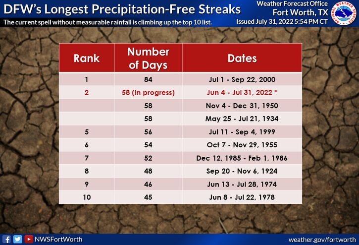
Thank goodness July is over with! It was our second hottest July on record. We're also working on day 59 with no measurable rain at DFW. And we now have 36 triple digit days in the record books this year. 20 days is average.
More heat is on the way this week along with a high grass fire danger and a very slight chance for an isolated shower the first half of today. Our next rain chance, Albeit slight, will be on Friday. Between now and then... heat and more heat!
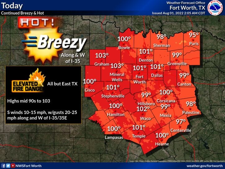
We're starting off this morning in the 80s with a few isolated showers dotting the area north of 635/170. Most will stay dry. Afternoon highs today will be around 102°. There's also a high grass fire danger, not just today but through the rest of this week, as a southerly wind blows at 10 to 20 mph. No heat advisories are in effect today, but they'll most likely return tomorrow and especially Wednesday and Thursday as temperatures warm between 102° and 105°!
The upper level wind-flow goes a bit more easterly Friday into the weekend. This will produce more cloud cover and a very slight chance for an afternoon or evening storm, especially on Friday. Afternoon highs will range between 99° and 101°.
Welcome to August ladies and gentlemen... our hottest month of the year! 53 days until fall!
*Yest Rain: 0.00; *Yest High: 104; Low: 83
*Today’s Averages: High: 97; Low: 77
*Record high: 107 (2011); Record low: 67 (1946)
*July rain: 0.00”; July deficit: 1.92"
*2022 Rain: 12.41”; 2021 deficit: 9.80"
*Sunrise: 6:40am; Sunset: 8:29pm
Today: Sunny, breezy and hot. Isolated shower or storm. HIgh grass fire danger. High: 102. Wind: South 5-10 mph.
Tonight: Clear and warm. Low: Low 80s. Wind: SSE 10-20 mph.
Tomorrow: Sunny, breezy and hot. High grass fire danger. High: 103. Wind: South 10-20 mph.
Wednesday and Thursday: Sunny, breezy and hot. Grass fire danger. High: 102-105.
Friday: Partly cloudy, a little cooler. An isolated shower of storm. High: 101.
Weekend: Mostly sunny and hot. Highs: 99-101.
Related

LISTEN on the Audacy App
Sign Up and Follow NewsRadio 1080 KRLD