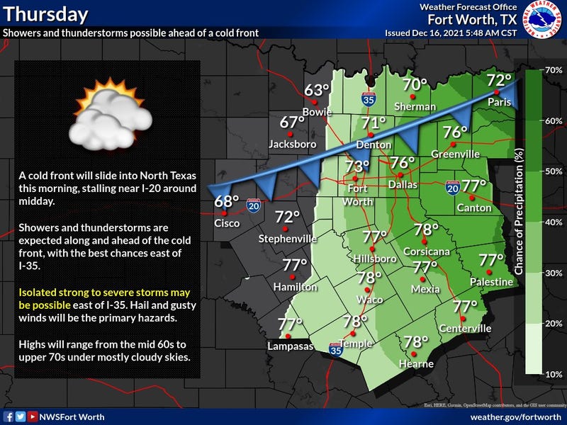

Is crazy warm out this morning for this time of the year! It WILL cool off by late morning, as a cold front is heading our direction at this hour. There are a few spotty showers developing to our north and NW. Not everyone will see rain this morning but about 30% of you may. Temperatures will fall into the fifties to low sixties from NW to SE by early afternoon. It may stay in the seventies SE of DFW all day long as the front stalls. Peaks of sunshine are possible.

The weak cold front lifts back to the north overnight, with a few showers and rumbles of thunder possible, especially along and north of highway 380. Low temperatures will be in the upper fifties to low sixties.
Most of tomorrow looks a-OK with very warm temperatures. Highs will reach the mid seventies again.
Our weather change arrives before midnight tomorrow. A strong cold front will plow through the area increasing our shower and thunderstorm chances. There could be a few strong ones around midnight into the early morning hours.
You'll wake up Saturday morning to a lot of wind and falling temperatures. Readings by Saturday late afternoon will be in the mid to forties, with a stiff north wind.
Sunday looks pretty decent, but you'll need to protect your plants and bring the pets indoors before going to bed Saturday night. Temperatures will fall near to near freezing by daybreak. Sunny and cool by afternoon, but temperatures will only warm to near 50゚.
Increasing clouds Sunday night with a chance of showers on Monday. It will stay cool with highs in the upper forties. As if now, the heaviest rain looks to be south of DFW through mid afternoon.
Skies clear and beautiful weather is in store for Tuesday and Wednesday. Highs will be in the upper fifties Tuesday, mid sixties Wednesday.
*Yest Rain: 0.00”; *Yest High: 80; Low: 67
*Today’s Averages: High: 58; Low: 38
*Record high: 83 (1908); Record low: 12 (1989)
*December rain: 0.02”; December deficit: 1.33"
*2021 Rain: 33.18”; 2021 deficit: 2.34"
*Sunrise: 7:24am; Sunset: 5:24pm
Today: Morning clouds and showers. Weak cold front. Peaks of afternoon sun. High: 60s north, 70s south. Wind: shifting north 10-20 mph.
Tonight: Cloudy and mild. Slight chance of showers. Low: 58-63.. Wind: South 5-15 mph.
Tomorrow: Mostly cloudy, windy and warm. Showers and storms after sunset. High: Mid to upper 70s. Wind: South 15-25, G30.
Saturday: Cloudy early, then peeks of sun by late afternoon. Windy and colder. High: Falling into the 40s.
Sunday: Increasing clouds late in the day. Chilly. High: Near 50.
Monday: Cloudy and cool. Chance of rain briefly returns. Heaviest south of DFW. Remaining chilly. High: Upper 40s.
Tuesday: Back to sunshine. Seasonable temperatures. High: Upper 50s.
Wednesday: Sunny and warmer. High: Mid to upper 60s.
Related

LISTEN on the Audacy App
Sign Up and Follow NewsRadio 1080 KRLD