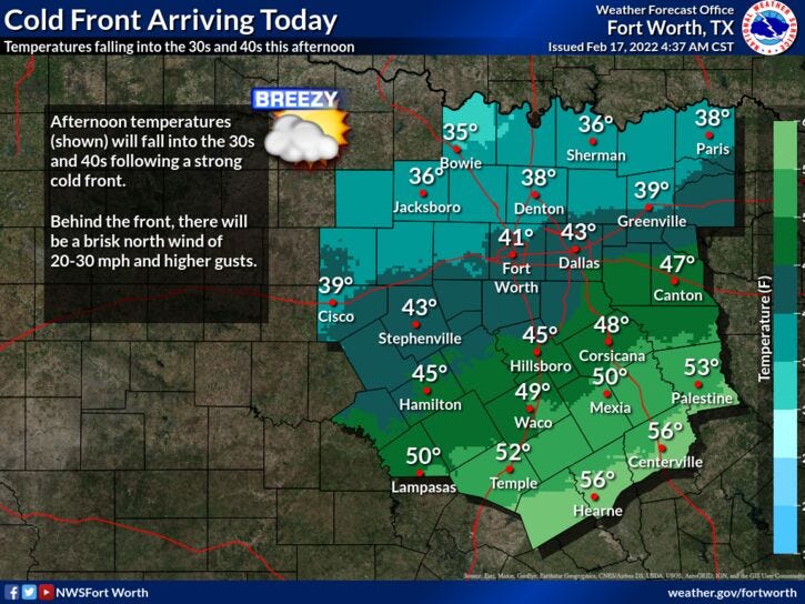

Rain will continue to move out from west to east over North Texas thru the next couple of hours. Nothing severe is expected. Don't forget to dress appropriately before heading out the door this morning. Our cold front is knocking at our door.

Temperatures at this hour range from 55 to 62゚, but readings drop drastically up towards the Red River, where temperatures are falling into the low 40s.
We've already reached our high temperature for the day. By mid to late morning, readings will be well down into the 40s. Factor in the 35 mph wind gusts, wind chills will be in the upper 20s by afternoon. Skies will slowly clear out by this evening.
Temperatures will continue to tumble into the low to mid 20twenties tonight. Be sure to protect your plants, pets, and pipes. Drip your faucets as well!
We stay cool tomorrow under a clear sky, but with less wind. Afternoon highs will be below average...low to mid 50s.
You ready for a nice weekend? After a light freeze Saturday morning, temperatures will rebound nicely into the low to mid 60s! It will be close to 70゚ by Sunday with a breezy south wind.
Our warm up continues into Monday. Some areas might touch 80゚! There also may be a few scattered showers around.
As you know, we live in North Texas and the weather can change in a matter of minutes. Well, that's what's gonna happen on Tuesday. A strong cold front will sag into the area sometime during the day and temperatures will plummet. By Wednesday morning, it's highly possible that we'll be slightly below freezing with precipitation moving into the area. If this occurs, which I give it a 39.4% chance right now, it would fall in the form of freezing rain and sleet. Temperatures we'll be hovering near the freezing mark all day long... If the data is correct I'm analyzing, the wintry mix won't move out until sometime Thursday and temperatures won't get above freezing until Friday. If this happens, it'll be a mess around here. This event is not in stone, but it definitely bears watching. I'll have updates into next week.
*Yest Rain: 0.00”; *Yest High: 68; Low: 61
*Today’s Averages: High: 61; Low: 41
*Record high: 88 (1959); Record low: 11 (1990)
*February rain: 1.39”; February deficit: 0.06"
*2022 Rain: 1.47”; 2022 deficit: 2.51"
*Sunrise: 7:09am; Sunset: 6:15pm
Today: Morning rain, turning windy and MUCH colder. A slow decrease in clouds later today. High: 60 early, falling through the 40s the rest of the day. Wind: NNW 15-25, G40 mph.
Tonight: Clear and cold. Less wind after midnight. Low: Low to mid 20s. Wind: NW 10-20 mph.
Tomorrow: Sunny and cool. High: Low to mid 50s.
Saturday: Light morning freezing. Sunny and seasonable. High: Low to mid 60s.
Sunday: Sunny, breezy and a bit warmer. High: Near 70.
Monday: Partly cloudy and VERY warm. Isolated showers and storms.
High: Near 80.
Tuesday: Increasing clouds. Another strong cold front. High: Near 70 early, then falling temperatures.
Wednesday: Cloudy, windy and COLD. Wintry mix possible. High: Mid 30s.
Related

LISTEN on the Audacy App
Sign Up and Follow NewsRadio 1080 KRLD