
We are starting off mainly in the seventies at this hour and nothing is showing up on radar, but that will be changing soon.
We hit 98゚ yesterday at DFW and will warm to that magic number again today. I will also be keeping an eye on radar to our north and west by late this afternoon and evening, as showers and thunderstorms will be approaching. A few of those may make it into north Texas by evening and linger through the overnight.
By Saturday morning, a cold front will be edging into the area. This front combined with daytime heating tomorrow and Sunday will produce scattered showers and thunderstorms. A few storms may be strong with gusty wind, small hail, and frequent lightning. If you have outdoor plans please keep an eye to the sky, especially if you'll be on on area lakes. Most of these storms will dissipate before midnight each evening. Afternoon highs will be in the low to mid 90s.
Next week's weather will be hot and humid with a few isolated afternoon and evening storms. High temperatures will be in the mid 90s.
*Yest Rain: 0.00”; *Yest High: 98; Low: 79
*Today’s Averages: High: 97; Low: 76
*Record high: 105 (1951); Record low: 56 (1967)
*August rain: 2.02”; August surplus: +1.29”
*2021 Rain: 24.04”; 2021 surplus +0.94”
*Sunrise: 6:50am; Sunset: 8:15pm
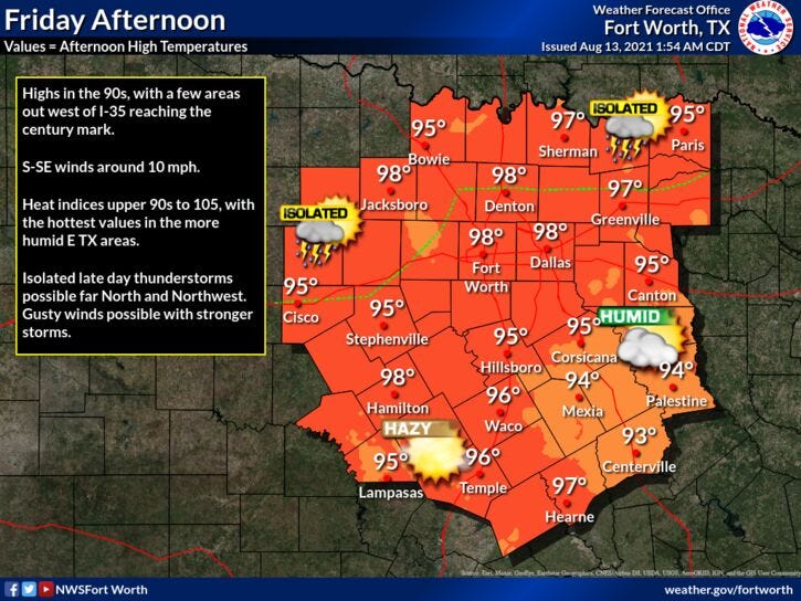
Today: Mostly sunny and hot. Isolated late day showers and storms. High: Upper 90s. Heat index: 103. Wind: South 5-10 mph.
Tonight: Isolated showers and storms. Partly cloudy and muggy. Low: Mid to upper 70s. Wind: South 5-10 mph.
Weekend: Partly to mostly cloudy. Not as hot. Scattered showers and storms. High: Low 90s.
Monday - Thursday: Partly cloudy, hot and humid. Isolated late day showers and storms. High: Mid 90s.
Related
