
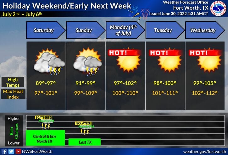
We've got a big holiday weekend coming up and there's a very slight chance of a shower or thunderstorm across the area on Saturday, south and east of us today and tomorrow and northeast of us on Sunday.
What's giving us this rain chance? An area of low pressure in the northwestern Gulf of Mexico will come ashore around the Houston-Galveston area by this time tomorrow. 3 to 5 inch rainfall totals are possible from Angleton all the way up towards the Galveston and Beaumont/Port Arthur area over the next 36 hours. This being said, if you have travel plans to the upper Texas coast, you are going to be dealing with a lot of rain until Sunday and the 4th of July. Your weather will improve along the beaches by then. If you want to stay out of the rain, I would highly suggest you head to the southern beaches, Port Aransas and South Padre Island. Very little rain is in the forecast for those areas.
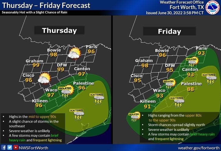
We've got another hot day today across north Texas, with afternoon highs in the mid to upper 90s. It'll be a little cooler tomorrow and Saturday due to the increase in humidity and cloud cover. Afternoon highs will only be in the low 90s for Friday and Saturday.
There's a very slight chance of a late day shower and storm southeast of DFW today and tomorrow. About a 25% coverage for us on Saturday and virtually no rain in the forecast Sunday through the middle of next week. Temperatures will start the heat up on Sunday with highs in the mid to upper 90s. We'll be at or above 100° on the 4th of July through the end of next week. Get ready for possible Heat Advisories to return as well.
* Yest Rain: 0.00”; *Yest High: 93; Low: 74
* Today’s Averages: High: 94; Low: 74
* Record high: 107 (1980); Record low: 64 (1899)
* June rain: 2.64”; June deficit: 0.95"
* 2022 rain: 12.41”; 2022 deficit: 7.77"
* Sunrise: 6:23am; Sunset: 8:41pm
Today: *Air Quality Alert* Mostly sunny and seasonable. Isolated late day storms SE of DFW. High: Mid to upper 90s. Wind: SE 5-10 mph.
Tonight: A few clouds and mild. Low: Low to mid 70s.Wind: SE 5-15 mph.
Tomorrow: Partly cloudy, hot and humid. Scattered late day showers and storms SE of DFW. High: Low 90s. Wind: South 5-15 mph.
Saturday: Partly cloudy, hot and humid. Slight chance for showers and storms. High: Low 90s.
Sunday: Partly cloudy and hot. Slight chance of late day showers and storms NE of DFW. High: Upper 90s.
4th of July: Mostly sunny and hot. High: upper 90s.
Tuesday and Wednesday: Sunny and continued hot. High: 99-102.
Related

LISTEN on the Audacy App
Sign Up and Follow NewsRadio 1080 KRLD