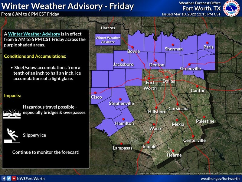

A Winter Weather Advisory is in effect for portions of North Texas from 6AM - 6PM Friday.
A Wind Advisory has also been issued from 9AM - 9PM Friday.
The National Weather Service says to plan on slippery road conditions, especially on bridges and overpasses. The hazardous conditions could impact the morning and evening commutes.
A Wind Advisory means that sustained winds of at least 20 to 30 mph are expected. Winds this strong can make driving difficult, especially for high profile vehicles.
No problems Thursday morning. Temperatures are in the upper thirties to low forties under a fair sky with light wind. It will be a beautiful day today with highs approaching 70゚

You know it is Texas, in March, and things can change in a matter of minutes. That's our weather story working our way after midnight tonight.
A very strong early March cold front will plow through the area after midnight. You will wake up tomorrow morning to wind gusts to 35 mph, temperatures in the low to mid thirties, and wind chills in the teens! I think the freeze line will be just north and west of DFW as you head out the door to work and school. Shortly after daybreak, a large area of precipitation will break out to the west and southwest of DFW in the form of light rain, light freezing rain, and light sleet. I believe we'll start off as a chilly rain here in DFW tomorrow morning, changing over to some brief-light freezing rain, then changing to sleet, and finally ending as a burst of snow during the mid afternoon. This all will occur between 9am and 6pm tomorrow.
The National Weather Service thinks the wintry precipitation will be heavy enough, that they have issued a Winter Weather Advisory north of DFW from 6am to 6pm tomorrow. Mark my words, I have a feeling this Winter Weather Advisory will be shifted south and west by tomorrow morning. This would include Dallas and Fort Worth, Weatherford, Granbury and Mineral Wells. It's not out of the question to see this advisory shifted farther south as well...Burleson, Cleburne, Mansfield, etc. Time will tell.
NOTE: It takes temperatures of 28゚ or below to cause problems on all roadways. 30 to 31゚ to start incing the bridges and overpasses. That's the main concern (bridges ond overpasses) across Dallas and Fort Worth and especially mid cities -> west or west of highway 377... Surface temperatures and radar trends will tell all.. It may be one of those days where you get to work and then all of a sudden you get sent home…Decisions to close schools will be difficult and challenging tomorrow morning. I wouldn't be surprised to see schools closed in McKinney, Frisco, Lewisville, Denton, and Decatur and points north by daybreak. It's gonna be a very difficult call for Fort Worth and Dallas.
Either way, there'll be some slick roads across parts of north Texas tomorrow, especially the northwestern half during the day into the evening. I again want to stress precipitation totals will be light, but it doesn't take much ice and snow to cause problems on the roadways.
To summarize, we'll go from a cold rain, to a brief bout of light freezing rain, to sleet, ending with a burst of snow northwest of a Paris to Rockwall to Hillsboro line. This does include Dallas and Fort Worth. Road conditions will deteriorate the farther west and north you get away from the Metroplex, but precipitation amounts will be on the lighter side. Temperatures will hover near freezing all day long and slightly below freezing off to the west of 35W and along and north of Hwy 380 in the Winter Weather Advisory areas.
The sky will clear rapidly Friday night and temperatures will plummet into the upper teens to mid twenties. Coldest temps will be in the light snow pack.
Sunny and cool for Saturday with highs near 52゚. Warming into the low to sixties on Sunday, back in the seventies on Monday. A little cooler Tuesday with highs in the mid sixties and back to the seventies we go into Wednesday.
*Yest Rain: 0.00”; *Yest High: 59; Low: 29
*Today’s Averages: High: 66; Low: 46
*Record high: 99 (1911); Record low: 15 (1948)
February rain: 0.20”; March deficit: 0.80"
*2022 Rain: 2.31”; 2022 deficit: 3.98"
*Sunrise: 6:45am; Sunset: 6:32pm
Today: Sunny and mild. High: Near 70. Wind: SE 10-20 mph.
Tonight: Increasing clouds. Turning windy and colder after midnight. Low: Mid to upper 30s. Wind: SE to north 20-30, G35 mph.
Tomorrow: *Winter Weather Advisory just north of DFW, 6am-6pm*…Cloudy, windy and cold. Wintry mix. Some accumulations, especially north and NW of DFW. High: Steady upper 20s (NW) to mid 30s (SE). Wind: North 20-30, G35.
Saturday: Morning hard freeze, then sunny and chilly. High: Low 50s.
Sunday: Sunny, windy, and warmer. High: Mid 60s.
Monday: Sunny, breezy and perfect! High: Low to mid 70s.
Tuesday: Mostly sunny and a tad cooler. High: Mid to upper 60s.
Wednesday: Sunny, windy and warm. High: Mid 70s.
Related

LISTEN on the Audacy App
Sign Up and Follow NewsRadio 1080 KRLD