
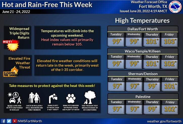
One more chance of a late afternoon or evening storm today and then rainfall chances shut off, as a large area of high pressure in the upper levels of the atmosphere builds back across the Lone Star State. Unfortunately, we are going to experience the hottest temperatures so far this year by the end of the week and into the upcoming weekend.
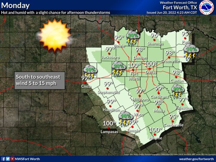
We're waking up to temperatures in the seventies this morning and nothing is showing up on radar at this time. This will change after 4 p.m. today, as a few isolated showers and storms break out just about anywhere across north Texas. Unfortunately, chances are very slim. Any storms that do form will contain gusty wind, brief heavy rain, dangerous lightning and rapidly dissipate by sunset.
This being said, I want to remind everybody this... If you plan on being out on any area lakes, whether you're paddle boarding, kayaking, paddle boating or even on a larger boat. Please stay weather aware. These thunderstorms can pop up in a matter of minutes and then quickly rain themselves out. Unfortunately, there were a few fatalities on area lakes this weekend due to these quick-hitting thunderstorms. Please check the radar every 15 minutes, so you can quickly get back onshore to seek shelter. Better yet, if you're going to be doing any non-motorized activity, stay CLOSE to the shore. There's no reason for anybody to lose their lives on area lakes due to pop-up thunderstorms. I'm very sorry for any loss of life over the weekend. Very tragic and sad.
After today, you won't have to worry about any storms for a while, as a large ridge of high pressure builds back across the state this week and into the weekend. Afternoon highs will warm to near 100 today through Wednesday...102 to 105 Thursday through the upcoming weekend. Morning lows will be between 75 and 80 degrees.
Looking ahead past day 7, a possible pattern change is on the way... with a cold front and a chance of showers and storms returning to the Lone Star State! Great news!
Have a blessed day and enjoy the weather, when you can, it's the only weather you've got.
_________________________________________________________
7-Day Headlines:
* Yesterday’s high at DFW: 99 degrees.
* One more chance of isolated storms today.
* Faucets shut off the rest of the week.
* Flirting with 100 degrees through Wednesday.
* Hottest temperatures of the year arrive Thursday - Sunday.
* Possible cool down and rain chances in 7 days!
* Summer arrives in 1 day.
_________________________________________________________
*Yest Rain: 0.00”; *Yest High: 99; Low: 78
*Today’s Averages: High: 92; Low: 73
*Record high: 104 (1953); Record low: 58 (1912, 1976)
_________________________________________________________
* June rain: 2.64”; June surplus: +0.23”
*2022 rain: 12.41”; 2022 deficit ”>
*Sunrise: 6:20am; Sunset: 8:39pm
Today: Partly cloudy and hot. Slight chance of an afternoon and evening shower or storm! High: Near 100. Heat index 103. Wind: South 5-15 mph.
Tonight: Mostly clear. Low: 75-80. Wind: SE 10-20 mph.
Tomorrow: Sunny and hot High: Near 100. Heat index 103. Wind: South 10-20 mph.
Tuesday and Wednesday: Sunny and hot. High: Near 100.
Thursday - Sunday: Sunny and hot. Highs: 100-104.
**Possible weather change LATE Sunday into Monday! A cold front may bring temperatures down next week and increase rain chances into Monday!**
Related

LISTEN on the Audacy App
Sign Up and Follow NewsRadio 1080 KRLD