
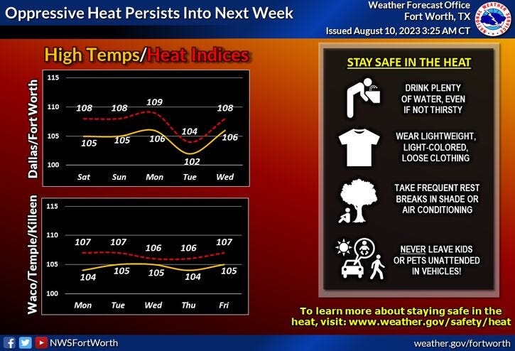
Yesterday, DFW hit 107 degrees and we should match that today, tomorrow, and through the weekend, as this bubble of high pressure grips all of north Texas. We may be flirting with record high temperatures this weekend and on Monday.
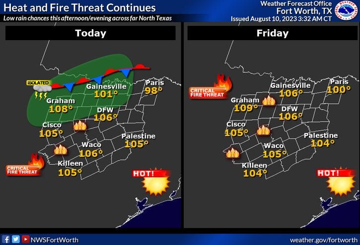
A few lucky ones yesterday saw a cooling shower and storm. Unfortunately, DFW Airport didn't measure a drop. Our deficit is now over 8 inches and climbing. A few isolated showers and storms are possible north and west of DFW late this afternoon and evening.
No changes in our weather pattern is expected next week except on Tuesday, as a weak cold front may slip the south of the area. If that happens, we may only hit 100° on Tuesday, mid-90s towards the Red River.
As of now, data doesn't show any rain with this front, but I will definitely keep one eye open for you. This front will lift back to the north on Wednesday and temperatures will climb above 105° once again through the end of next week.
*Yest Rain: 0.00”; Yest High: 107 Low: 83
*Today’s Averages: High: 97; Low: 77
*Record high: 110 (1936): Record low: 63 (1989)
*August Rain: Trace; Deficit: 0.54"
*2023 Rain: 14.83"; Deficit: 8.08"
*Sunrise: 6:49am; Sunset: 8:18pm
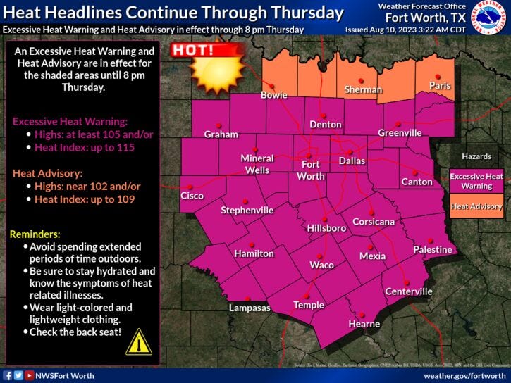
Today: *Excessive Heat and Red Flag Warnings * Partly cloudy, windy and hot. Isolated evening storms west of I-35W. High grass fire danger. High: 107. Wind: SSW 10-20 mph.
Tonight: Partly cloudy, warm and windy. Low: 78-85. Wind: SW: 10-20 mph.
Friday: *Excessive Heat Warnings likely* Mostly sunny, breezy and hot. High grass fire danger. High: 107. Wind: SSW 10-20 mph.
Weekend: *Excessive Heat Warnings likely* Mostly sunny, breezy and hot. Grass fire danger. Highs: 106-108.
Monday - Wednesday: *Excessive Heat Warnings likely* More of the same. Mostly sunny and hot. Grass fire danger. Highs: 103-107.
Related

LISTEN on the Audacy App
Tell your Smart Speaker to "PLAY 1080 KRLD"
Sign Up to receive our KRLD Insider Newsletter for more news