
LATEST WEATHER UPDATE: A very strong upper-level disturbance coupled with a weak cold front and Big Time surface heating today has produced an area of storms just north of the Red River. These will travel Southeast through the evening and may expand between the blue lines. If this happens, damaging wind will be the main threat as they move into North Texas between 10 p.m. and 1 a.m. from north to south.
Last updated on Friday, Sept. 8 at 6:47 p.m.
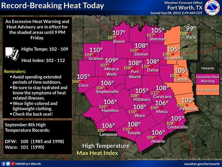
Summer's going out with a bang Friday, with record-shattering heat. Will this be the last triple-digit day of 2023, or will it be Saturday? Either way, we'll end the summer with either 53 or 54 triple-digit days, which would rank fourth all-time in North Texas.
Friday will feature record-breaking heat with an afternoon high of around 108 degrees. The record for Sept. 8 was set three separate times in the 1900s at 100 degrees. There is also a chance for scattered severe storms late Friday through early Saturday as a strong disturbance rolls out of Oklahoma. The Storm Prediction Center has put areas along and east of Interstate 35W in a Level 2 (slight) out of 5 for severe storms. The threats include large hail and damaging wind.
As of Friday morning, it looks like the more widespread coverage will be in East Texas. Keep an eye on the sky, especially if you're heading to a high school football game along our Red River counties and east of Dallas after 7 p.m. If we see any rain in Dallas-Fort Worth, it'll be towards midnight through 6 a.m. Saturday.
The majority of the weekend looks OK with slightly cooler temperatures. Afternoon highs will be in the mid to upper 90s. There will be some scattered strong storms working their way in from the northwest, mainly west of I-35W late Sunday evening. Right now, I think they'll stay well west of Fort Worth.
Drought relief comes next week folks as a big weather change is on the way. This upper-level ridge of high pressure that's giving us the brutal heat, will move well to the west of Texas next week. This will allow a northwesterly flow in the upper levels of the atmosphere to set up across the state. A cold front will drift through the area late Monday night into Tuesday morning coupled with a strong upper-level disturbance.
This will produce widespread shower and thunderstorm activity late Monday into the first half of Tuesday. We'll still warm into the mid to upper 90s on Monday, but most areas will struggle to get above 80 degrees on Tuesday with slow clearing by afternoon. A couple more disturbances will roll through the area Wednesday through Friday keeping rain chances in the forecast. It's still too early to tell where the heaviest rain will fall. It all depends on the track of the upper-level disturbances.
The more cloud cover and widespread rain we see through the period, the cooler the temperatures will be. I'm going with highs near 80 degrees on Wednesday and Thursday. It may be a few degrees cooler or a few degrees warmer depending on the sunshine. I'll know a lot more as we work our way into early next week on the track of the upper-level disturbances and the temperatures. One thing is a guarantee, readings will be below average Tuesday through Friday. Our average high right now is 91 degrees and will fall another degree next week.
Please remember to keep an eye to the sky late Friday evening, especially north and east of the Dallas-Fort Worth area. A lot of you may be attending high school football games.
7-Day Headlines
* DFW reached 107 degrees yesterday. Another record broken.
* 52 triple-digit days in 2023.
* Excessive Heat Warning today. Record high will be shattered.
* Scattered, severe storms late Friday into Saturday morning. Threats: Hail and wind.
* A bit cooler this weekend, but still hot.
* BIG pattern change coming next week. Welcome rain and cooler temps.
_____________________________________________________
*Thursday rain: 0.00"; Yest High: 107 (record); Low: 81
*Friday's averages: High: 91; Low: 71
*Record high: 100 (1972, 1985, 1998): Record low: 55 (1998)
______________________________________________________
*August rain: 0.20"; Deficit:
*2023 Rain: 15.03"; Deficit:
*Sunrise: 7:07am; Sunset: 7:44pm
Friday: *Excessive Heat Warning* Mostly sunny and hot. Record (100) breaking heat. High: 108. Wind: SW 10-20 mph.
Tonight: Increasing clouds. Scattered severe storms. Level 2 (slight risk) out of 5 in place, mainly along and east of I-35W. Threats: Large hail and damaging wind. Low: Low mid to upper 70s. Wind: East 10-25 mph.
Tomorrow: Morning showers and storms, partly cloudy by afternoon. Not as hot, but very humid. High: Mid to upper 90s. Wind: East 10-20 mph.
Sunday: Partly cloudy, and warm. Scattered storms by late evening, west of I-35W. High: Mid to upper 90s.
Monday: Partly cloudy and hot. Scattered showers and storms by late evening through the overnight. Rain may be heavy at times along a cold front. High: Mid to upper 90s.
Tuesday: Cloudy and MUCH cooler. Morning showers and storms. High: Near 80.
Wednesday and Thursday: Mostly cloudy and pleasant. Scattered showers and storms likely. High: Near 80.
LISTEN on the Audacy App
Tell your Smart Speaker to "PLAY 1080 KRLD"
Sign Up to receive our KRLD Insider Newsletter for more news
Follow us on Facebook | Twitter | Instagram | YouTube