
We hope you enjoyed the slightly cooler temperatures this weekend because the triple digits are returning this week and into the upcoming weekend. At least the humidity will remain on the low side during the afternoon hours, so we won't be dealing with oppressive heat index values.
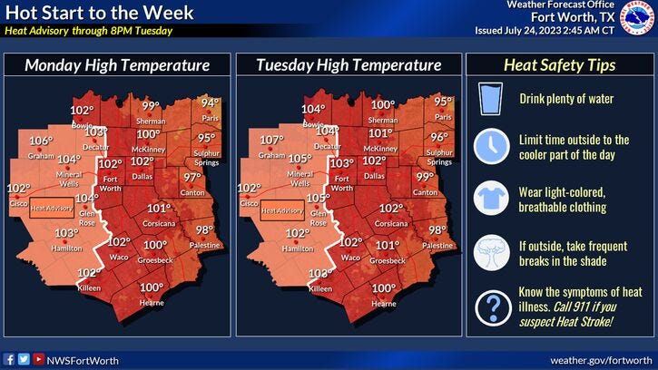
Heat advisories are now in effect just west of the Dallas-Fort Worth area today and tomorrow where temperatures will range between 103° and 106°. DFW will be a couple of degrees cooler.
These heat advisories may expand eastward Wednesday through Friday to include DFW. Afternoon highs will range between 100° to 106° from east to west.
The wind will also pick up and gust to 25 miles per hour, especially west of Fort Worth. This will create an elevated grass fire danger in these areas.
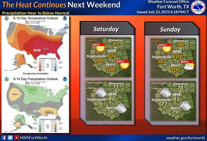
No changes are in our forecast into the weekend. Plenty of sunshine with afternoon highs between 100° and 103°. Unfortunately, no rain is in the forecast over the next 7 days, as our deficit continues to climb at DFW.
*Yest Rain: 0.00"; Yest High: 98 Low: 73
*Today’s Averages: High: 97; Low: 77
*Record high: 108 (1954, 1977): Record low: 64 (1911)
*July Rain: 0.47"; Deficit: 1.23
*2023 Rain: 14.83"; Deficit: 7.16
*Sunrise: 6:36am; Sunset: 8:33pm
Today: *Heat Advisory, west of DFW* Sunny and hot. High: 100-104. Wind: SE 5-10 mph.
Tonight: Clear and warm. Low: Mid to upper 70s. Wind: SE 5-10 mph.
Tomorrow: *Heat Advisory, west of DFW* Sunny and hot. High: 100-105. Wind: SSE 10-20 mph.
Wednesday - Friday: Sunny, breezy and hot. High grass fire danger west of I-35W. Highs: 100-105.
Saturday: Sunny and continued hot. High: 100-103.
Sunday: Sunny and a tad cooler. High: Near 100.
Related

LISTEN on the Audacy App
Tell your Smart Speaker to "PLAY 1080 KRLD"
Sign Up to receive our KRLD Insider Newsletter for more news