
Another below average morning is being felt across north Texas, as temperatures have fallen into the upper sixties to lower seventies at this hour. Theres not a cloud in the sky but there's plenty of Saharan dust! This dust will linger in the air the next few days across north Texas making for some wild sunrises and sunsets. Also, I would limit your outdoor activity during the afternoon hours due to the poor air quality.
Not much going on today in the world of weather through the weekend, with afternoon highs in the mid nineties, morning lows in the mid seventies. There may be a few isolated late day showers and storms about 50 miles southeast of Dallas and Fort Worth through Friday. A little bit better chance a couple of county rows (north of hwy. 380) butted up against the Red River this weekend between 5:00 p.m. and 9:00 p.m.
Our next significant weather change arrives next week, as a cold front slowly sags through the area. This will promote numerous showers and strong thunderstorms across north Texas. Right now, I'm thinking Monday and Tuesday will be our best rain chances, but they could linger into Wednesday and Thursday, depending where the cold front stalls. Cooler temperatures will also prevail with afternoon highs only in the eighties! Unheard of for mid July!
*Yest Rain: 0.00”; *Yest High: 93; Low: 72
*Today’s Averages: High: 95; Low: 76
*Record high: 107 (1925, 1980); Record low: 62 (1990)
*July rain: 0.99”; July deficit: 0.14
*2021 Rain: 21.51”; 2021 surplus +0.09”
*Sunrise: 6:30am; Sunset: 8:38pm
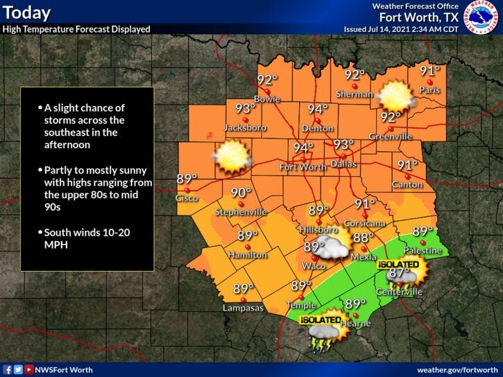
Today: Mostly sunny, breezy, hazy and hot. An isolated late day shower or storm (SE of DFW). High: Mid 90s. Wind: South 10-20 mph.
Tonight: Clear, hazy, and muggy. Low: Mid 70s. Wind: South 10-20 mph.
Tomorrow: Mostly sunny, hazy, breezy and hot. High: Mid 90s. Wind: South 10-20, G25 mph.
Friday: Partly cloudy, breezy and hot. High: Mid 90s.
Weekend: Partly cloudy and hot. A few late day showers and storms. High: Mid 90s.
Monday and Tuesday: Mostly cloudy and cooler. Another RARE July cold front lingers. Numerous showers and strong. High: Mid to upper 80s.
Related
