
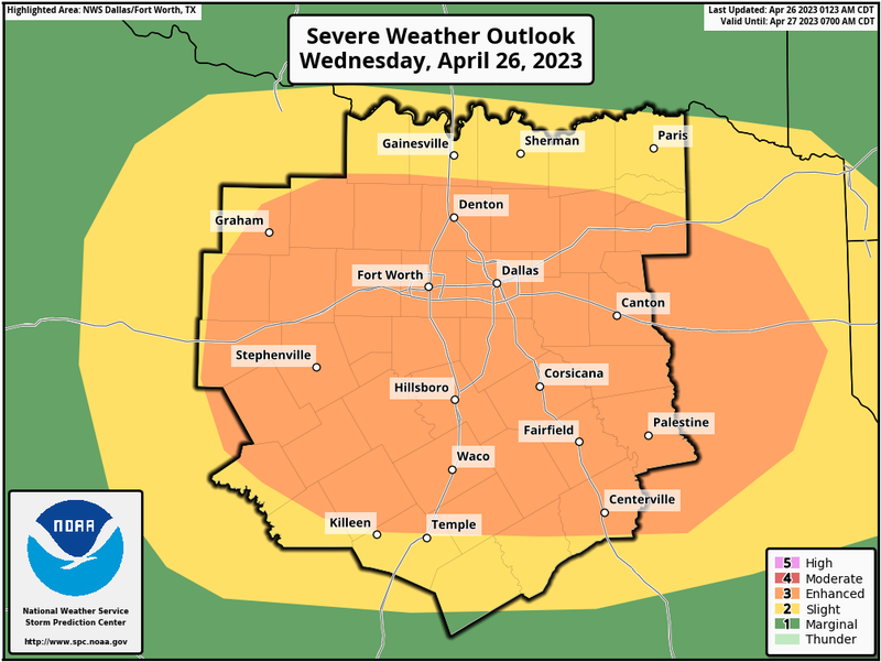
The National Weather Service has issued a Tornado Watch for parts of North and Central Texas until 10 p.m. Wednesday. The Watch includes Ellis, Hood, and Johnson counties.
Due to the possibility of severe weather, Dallas College will close at 5 p.m. Wednesday. Classes and services that can be conducted online will continue in that capacity.
The severe weather is expected to take place mostly south of Interstate 20 starting at 4 p.m. and ending by 9 p.m.
As a cold front sweeps through the area, it will clear things out from west to east Thursday morning. Sunny and cool weather is forecast through the day with a high near 70 degrees.
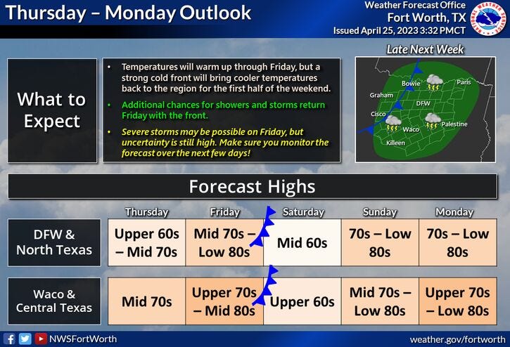
Most of Friday looks uneventful until evening. Afternoon highs will approach eighty degrees. Showers and storms are back in the forecast, a few could be strong Friday evening as another cold front sweeps through the area before daybreak Saturday. The rain will end from west to east by noon on Saturday.
Saturday's highs will be in the mid to upper 60s with a cool north wind gusting to 30 mph.
Sunday looks nice with morning lows into the 50s...afternoon highs will warm into the mid-70s.
Monday and Tuesday's weather look just as nice with a gusty southerly wind. Highs will approach 80 degrees on both days.
Reminder: Please stay weather aware later this afternoon through the evening hours. Myself and our staff at KRLD will be monitoring the weather for you and will give you updates as conditions warrant, especially this evening.
*Yest Rain: 0.01"; Yest High: 73; Low: 549
*Today’s Averages: High: 78; Low: 58
*Record high: 90 (1955); Record low: 39 (1910)
*April Rain: 1.64"; Deficit: 0.94"
*2023 Rain: 9.76"; Deficit: 1.42"
*Sunrise: 6:45am; Sunset: 8:07pm
Wednesday: Afternoon and evening showers and storms, then severe weather threat ramps up (4pm-7pm), mainly south of I-20. Threats: Large hail, damaging wind, and isolated tornadoes. High: 63-72. Wind: ESE 10-20 mph.
Wednesday night: Cloudy and mild. Severe threat shifts south of I-20 after 7 p.m. All modes of severe weather are possible. Low: Mid to upper 50s. Wind: North 10-20 mph.
Thursday: Morning showers, then decreasing clouds by afternoon. Cooler with lower humidity. High: Near 70. NW 10-20 mph.
Friday: Sunny through most of the day, then increasing clouds by evening. String storms possible b4 midnight. High: Near 80.
Saturday: Morning showers, then decreasing clouds by afternoon, windy and cooler. High: Mid to upper 60s.
Sunday: Sunny and perfect. High: Mid to upper 70s.
Monday and Tuesday: Sunny, windy and warm. High: Near 80.
Related

LISTEN on the Audacy App
Tell your Smart Speaker to "PLAY 1080 KRLD"
Sign Up to receive our KRLD Insider Newsletter for more news