
UPDATE: 6:46 P.M.
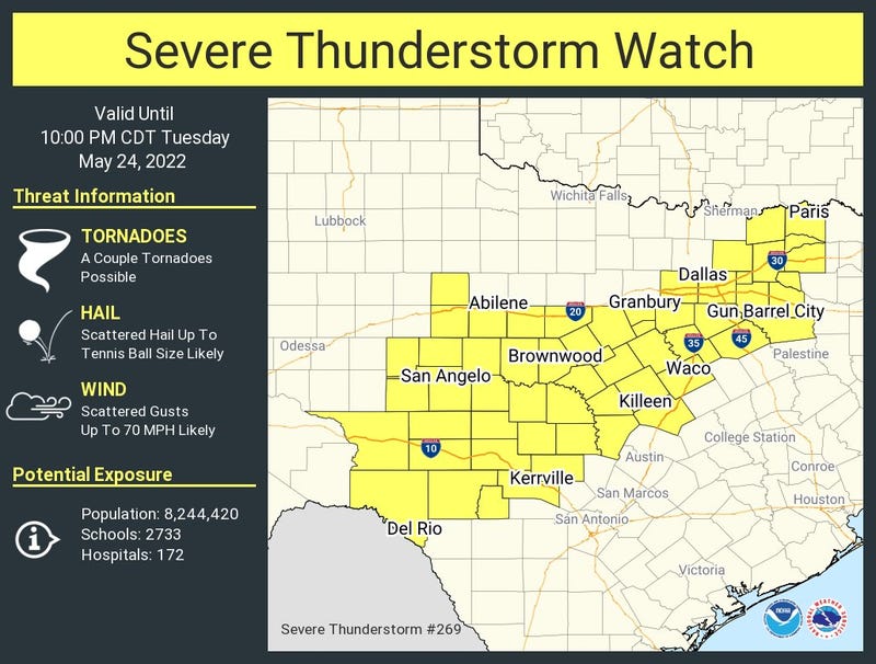
As of late Tuesday afternoon, most if not all of the severe weather looks likely to remain about 30 to 50 miles south of the Dallas-Fort Worth area this evening. We can thank the rain that fell earlier today for stabilizing and cooling off the atmosphere. However, a Severe Thunderstorm Watch remains in effect until 10 p.m. in the yellow boxes below.
There are three areas of storms to watch.
The first wave is moving into our top two North Texas county rows towards the Red River. These are not severe as of Tuesday late afternoon, because the air has stabilized from earlier convection. There will be some heavy rain and some small hail but the severity threat looks low. However, keep an eye on the southern flank of this line, just to the west of Dallas and Fort Worth. This area may enhance over the next couple of hours and move through the DFW area. A few of these storms could become severe, but again, this area is rain-cooled as well.
The second area storms are working their way through the Abilene and Big Country area and will continue to race east-southeast and intensify through Tuesday evening. Two county rows south of Interstate 20 (Corsicana to Hillsboro to Granbury) need to watch this line by mid to late evening. This is where the larger hail and an isolated tornado threat exist.
The third area of storms is way out in West Texas around Lubbock. This area will race east and arrive across North Texas, in a weakened state, shortly before midnight giving the area more welcome rain. The good news is that the atmosphere will continue to be worked over in DFW and surrounding counties, so the severe weather threat will remain low.
Average rainfall totals across North Texas will range between 2" to 3".
To summarize, the severe weather threat looks to remain south of Dallas & Fort Worth this evening (large hail and isolated tornadoes). Please stay weather aware in this area between 8 p.m. and 2 a.m.
UPDATE: 11:15 a.m.
Non-severe moderate rain continues to slowly press East, but the bulk of it is heading northeast. Nothing severe is expected at this time. This may stabilize the atmosphere a little bit keeping the severe weather threat a little bit lower this evening, but that's not in stone.

UPDATE: 8:30 a.m.
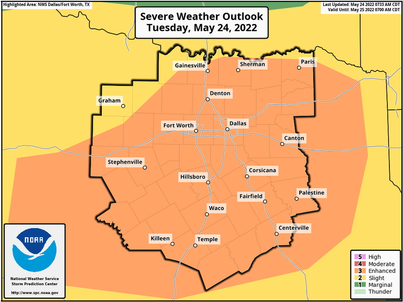
The Storm Prediction Center has upgraded the severe weather threat to a level 3 out of 5 for all of north Texas.
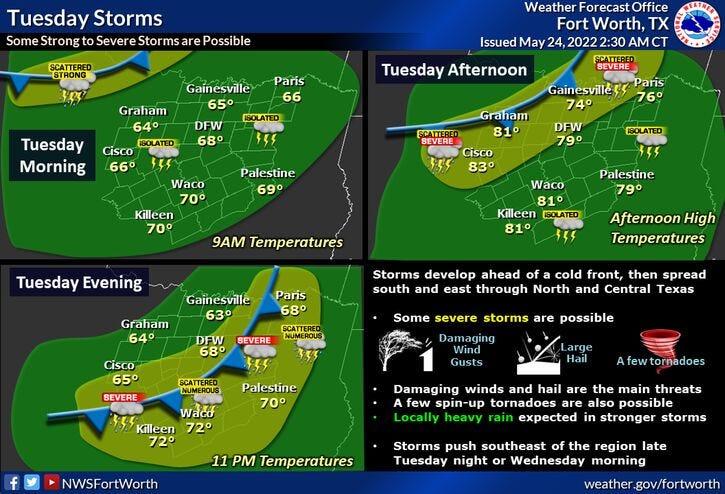
Things will start to deteriorate late this afternoon northwest of the area and across the rest of north Texas this evening. Hail, wind, and isolated tornadoes are the threats.
Some of you are seeing some very heavy rain this morning, mainly west of I-35 and north of Highway 380. These storms are not severe, but are dropping some very heavy rain. These storms will continue to move into southern Oklahoma through the morning. For the rest of north Texas, there's a chance for some scattered showers and isolated storms through the morning into early this afternoon, but the big weather story will arrive late on this afternoon into the evening.
A large area of showers and thunderstorms will develop along a cold front about 200 miles northwest of DFW this afternoon. These storms will congeal into a good old fashioned Texas squall line. Some of these storms will become severe with hail and wind being the primary threats, but isolated tornadoes are never out of the question in severe thunderstorms. This long line of storms will plow through the area late this afternoon through the early morning tomorrow. Rainfall totals will be between 1" and 3". There is a Flash Food Watch east of DFW through tomorrow morning.
We're starting off this morning in the upper sixties. We'll reach the low eighties in some areas by this afternoon. Clouds will be around most of tomorrow with high temperatures only in the low seventies after morning lows in the low sixties.
Thursday looks beautiful with plenty of sunshine, low humidity with highs in the low eighties.
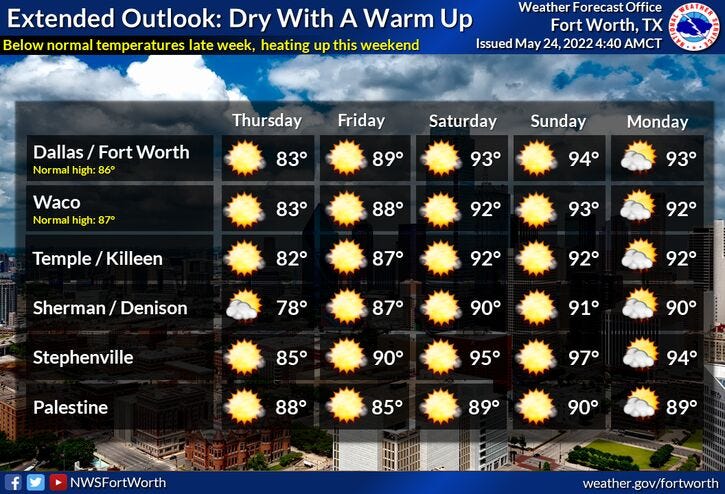
The warm up starts on Friday. We will all enjoy sunshine with highs near average into the middle eighties.
Temperatures will continue to warm up into the holiday weekend. We'll be near 90 on Saturday, low to mid 90s Sunday and Monday, with heat index values approaching 100゚. This hot weather pattern looks to extendnd into most of next week.
Please stay weather aware late this afternoon through early tomorrow morning, as a level 2 out of 5 for severe weather is in the forecast. I will be watching and monitoring as usual.
*Yest Rain: 0.04”; *Yest High: 79; Low: 60
*Today’s Averages: High: 86; Low: 67
*Record high: 96 (1996); Record low: 54 (1940)
* May rain: 1.67”; May deficit: 1.92"
*2022 rain: 8.44”; 2022 deficit: 6.96"
*Sunrise: 6:24am; Sunset: 8:27pm
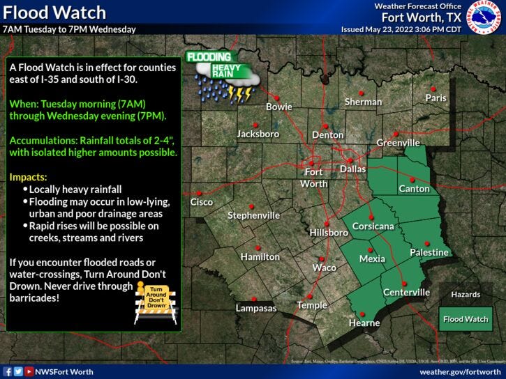
**FLOOD WATCH EAST OF DFW TODAY**
Today: Scattered morning storms, then numerous storms, some severe late this afternoon and evening. Level 2 out of 5. Threats: Hail, wind and isolated tornadoes. High: Low 80s. Wind: South 15-25 mph.
Tonight: Scattered storms, some severe, ending before daybreak. Level 2 out of 5. Cooler. Low: Low 60s. Wind: WSW 15-25 mph.
Tomorrow: Cloudy and cooler. A slow decrease in clouds by evening. High: Low 70s. Wind: NW 10-20 mph.
Thursday: Sunny and nice. Low humidity. High: Low 80s.
Friday: Sunny and warmer. Highs: Mid 80s.
Saturday- Memorial Day: Sunny, windy and hot! Highs: Low to mid 90s. Heat index values near 100.
Related

LISTEN on the Audacy App
Sign Up and Follow NewsRadio 1080 KRLD