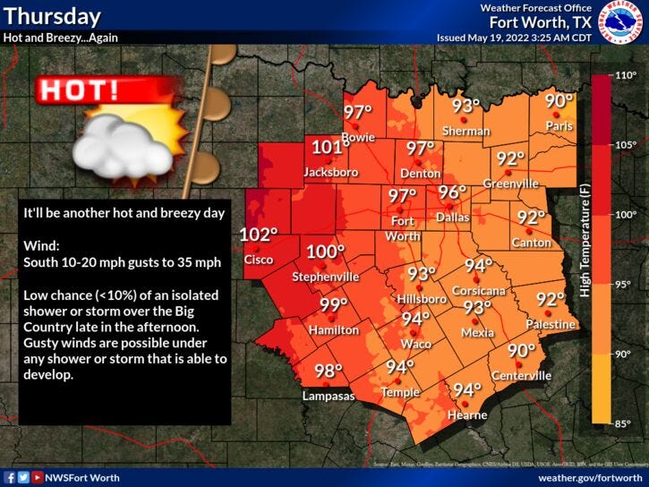

We're waking up to temperatures in the seventies this morning. Sunshine will dominate our weather today with highs in the mid-to-upper 90s.
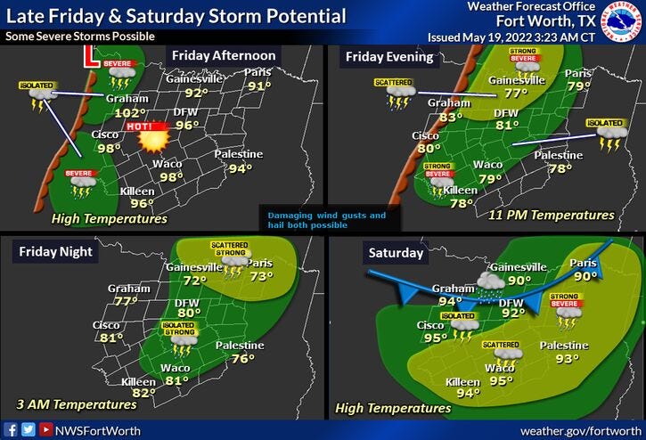
Clouds roll in tonight with lows in the low 70s. Partly cloudy tomorrow, windy and hot with highs back in the mid-90s. By tomorrow evening, the dryline will produce scattered showers and storms to our west, some of them could become severe as they move across north Texas. Hail and wind will be the threats.
Partly cloudy conditions will dominate on Saturday with highs in the low 90s. By Saturday late afternoon into the evening hours, a strong cold front will move through the area. This will produce more showers and storms across north Texas. A few could be strong. Wind and cooler temperatures will filter in behind the front. Temperatures will fall into the mid-50s by Sunday morning under a mostly cloudy sky. Partial clearing by afternoon with highs only in the low 70s!
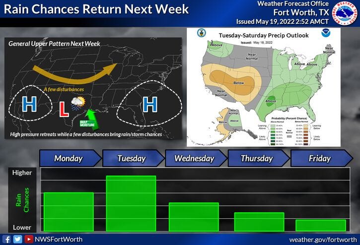
Our next weather change arrives Monday through Wednesday of next week, with a good chance for showers and storms, some rain could be heavy at times. Afternoon highs will be in the mid-to-upper 70s.
*Yest Rain: 0.00”; *Yest High: 96R; Low: 73
*Today’s Averages: High: 85; Low: 66
*Record high: 99 (2008); Record low: 50 (1983, 2002)
* May rain: 1.63”; May deficit: 1.07"
*2022 rain: 8.40”; 2022 deficit: 6.21"
*Sunrise: 6:26am; Sunset: 8:24pm
Today: Morning storms east of DFW, afternoon sun. Windy and hot. High: Mid to upper 90s. (Record 99 degrees). Wind: SSE 15-25, G30 mph.
Tonight: Increasing clouds, windy, mild and muggy. Low: Low to mid 70s. Wind: SSE 15-25, G30 mph.
Tomorrow: Morning clouds, afternoon sun. Windy and hot. High: Mid 90s. Wind: SSE 15-25 mph.
Tomorrow night: Scattered showers and storms. Some severe. Threats: Hail and wind. Low: Low 70s.
Saturday: Partly cloudy and hot. Scattered storms by late afternoon and evening along a strong cold front. Severe potential will be monitored. High: Low to mid 90s.
Sunday: Mostly to partly cloudy, breezy and cooler. Low: Mid 50s; High: Low 70s.
Monday - Wednesday: Mostly cloudy and mild. Scattered showers and storms. Rain could be heavy at times. Highs: Mid to upper 70s.
Related

LISTEN on the Audacy App
Sign Up and Follow NewsRadio 1080 KRLD
Facebook | Twitter | Instagram