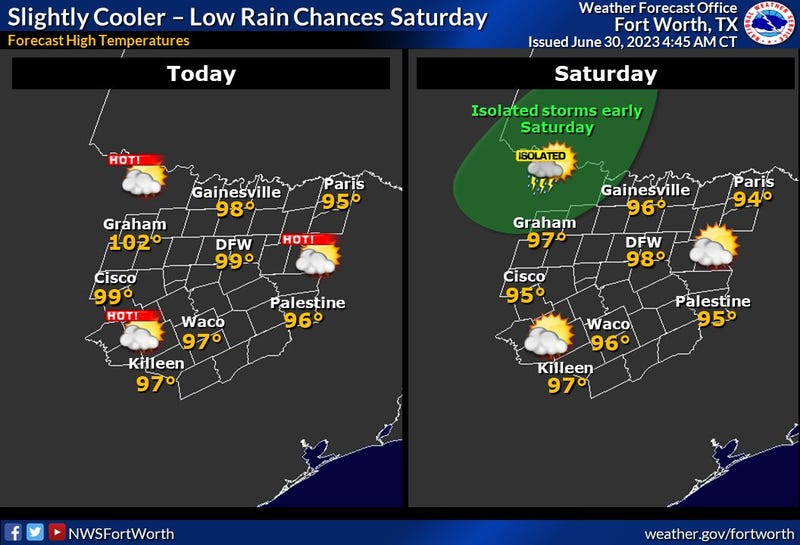

It's finally happening! The upper level ridge of high pressure is shifting to the east of north Texas. What does this mean for us? First it means the heat advisories and excessive heat warnings are moving east along with it. However, it'll still feel like it's close to 105° today through the upcoming weekend.
Today will most likely be our last triple-digit temperature over the next 7 days. Afternoon highs today will top out at 100 degrees.
Starting tomorrow, a weak trough of low pressure will slide close to the Red River Valley. By Sunday, lasting through the 4th of July, this trough combined with afternoon heating will allow isolated showers and storms to form between I-20 and the Red River Valley through the period. Coverage will be 20%. Afternoon highs will reach the mid to upper nineties. Heat index values will approach 105 degrees.
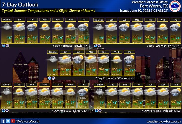
Wednesday and Thursday will still be rather warm, with highs in the mid to upper nineties. However, slightly better rain chances may arrive by late Thursday, as a stronger trough of low pressure digs deeper into north Texas.
*Yest Rain: 0.00"; Yest High: 101: Low: 80
*Today’s Averages: High: 94 Low: 74
*Record high: 107(1980): Record low: 64 (1899)
*June Rain: 0.78"; Deficit: 2.81"
*2023 Rain: 14.36"; Deficit: 5.82"
*Sunrise: 6:23am; Sunset: 8:41pm

Today: Sunny and hot. High: Near 100. Heat index: Near 105. Wind: SSW 10-20 mph.
Tonight: Clear and warm. Low: 78-82. Wind: SSE 10-15 mph.
Saturday: Sunny and hot. High: Upper 90s. Heat index: Near 105. Wind: SSE 10-20 mph.
Sunday: Partly cloudy and a tad cooler. Scattered late day storms. High: Mid 90s.
Monday: Partly cloudy and warm. Scattered late day showers and storms. High: Mid 90s.
4th of July: Partly cloudy and warm. Isolated late day showers and storms. High: Mid to upper 90s.
Wednesday: Partly cloudy and warm. Isolated late day showers and storms. High: Mid to upper 90s.
Thursday: Partly cloudy and warm. Scattered late day showers and storms. High: Mid to upper 90s.
Related

LISTEN on the Audacy App
Tell your Smart Speaker to "PLAY 1080 KRLD"
Sign Up to receive our KRLD Insider Newsletter for more news