
UPDATE (6/12) 1:00 P.M.
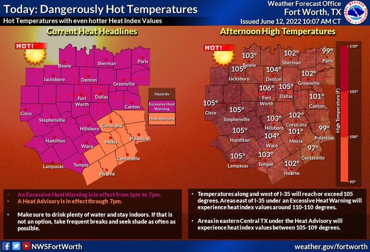
Very dangerous heat index values and surface temperatures will affect all of North Texas on Sunday. As of 10 a.m. we were already at 89° with a heat index of 96°. Dewpoint is at 72°! That's oppressive folks and it's just going to get worse throughout the day.
When you factor in humidity and temperatures between 104° and 106°, the heat index value will be well above 112°. Please limit your outdoor activity during peak heating hours.
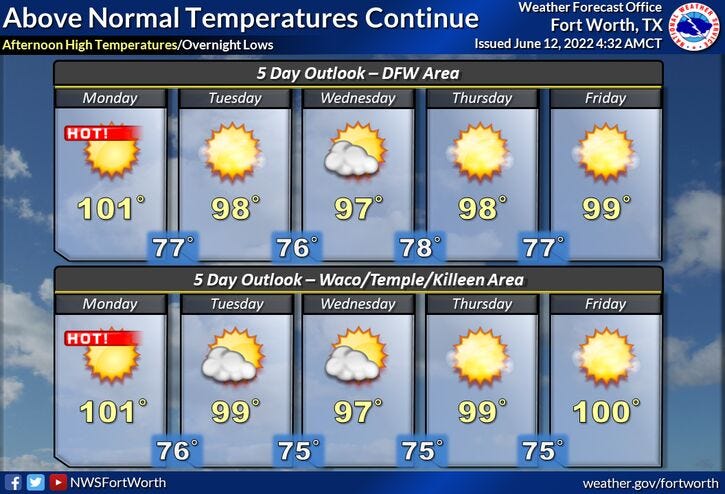
Temperatures will come down a little bit next week, but readings will still be well above average!
UPDATE (6/11) 1:00 P.M.
Just think, we're not even officially in summer yet. It's 10 days away, but temperatures will continue to be well above average for this time of the year.
Our average high is creeping up close to 92°. We'll be a good 10°+ above average this weekend and into early next week. Temperatures may drop a few degrees by the middle of next week, as his ridge of high pressure drifts to the east of Texas - Briefly. Unfortunately, it's going to creep back to the west right over Texas by the end of next week and into the following weekend.
Absolutely no rain is in the forecast at least for the next 7 to 10 days and maybe even longer than that.
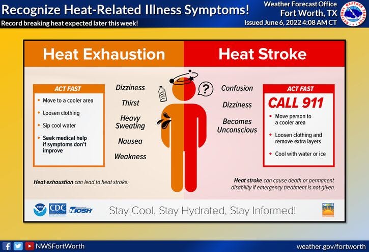
Please remember to drink plenty of water and take frequent breaks if you're going to be working outdoors. Find shade whenever possible. Wear light-colored loose-fitting clothing and don't forget the sunscreen and a hat. And most importantly, make sure your pets have a cool place to stay. If you do have to leave them outdoors for a few hours, make sure they have shade and plenty of water.
We're waking up to temperatures mainly in the 70s across North Texas with a north wind taking over behind an outflow boundary rushing out of a huge cluster of storms in Eastern Oklahoma. Unfortunately, most of North Texas missed out on the rain with the exception of the Highway 82 corridor bordering the Red River.
A severe thunderstorm watch is in effect until 8 a.m. along and east of Central Expressway and north of Interstate 30. Unfortunately, all of North Texas has missed out on the rain and this is our last chance for a while!
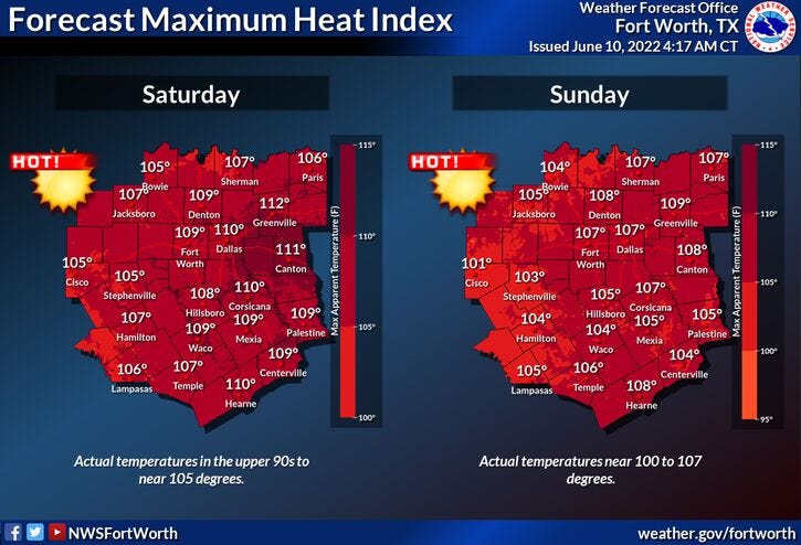
A strong area of high pressure in the upper levels of the atmosphere will continue to build over north Texas this weekend. As of now, it looks like the record high of 101° will not be broken today but we'll warm into the upper 90s with a southwest wind 15 to 25 mph. Tomorrow and Sunday, the record highs are 103°. We'll come close each day, but heat index values will be 105 degrees plus. Please make sure you stay hydrated if you're going to be working outdoors and take frequent breaks in the shade.
This upper level high will drift to the east of north Texas by the middle of next week, shaving a few degrees off the afternoon highs but we're still going to be hot with readings in the mid-to-upper 90s. Humidity levels will drop off a little bit too.
More of the same as we head towards the following weekend with afternoon highs in the mid-to-upper 90s. As of now, no rain is in the forecast, but that is subject to change because it's so far out.
*Yest Rain: 0.00”; *Yest High: 94; Low: 73
*Today’s Averages: High: 91; Low: 71
*Record high: 101 (1911, 1936); Record low: 58 (1955)
* June rain: 2.64”; June surplus: +1.70”
*2022 rain: 12.41”; 2022 deficit: 5.37"
*Sunrise: 6:19am; Sunset: 8:36pm
Today: Partly cloudy, hot and humid. High: Mid to upper 90s. Heat index near 100. Wind: SW 15-25 mph.
Tonight: Fair and muggy. Low: Upper 70s. Wind: SSE 5-10 mph.
Tomorrow: Sunny, hot and humid. High: Near 100. Heat index near 105. Wind: SW 10-20 mph.
Sunday and Monday: Sunny, breezy, and hot. Near record heat. Highs: 100-104. Heat index +105 degrees.
Tuesday - Thursday: Sunny, breezy and continued hot. High: Near 95-100.
Related

LISTEN on the Audacy App
Sign Up and Follow NewsRadio 1080 KRLD