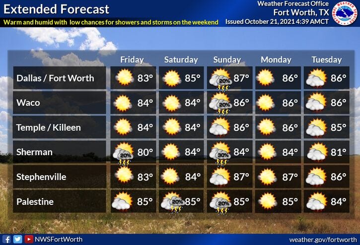

Absolutely nothing going on in the weather world for the next 6 days!
We will experience above average temperatures and below normal precipitation through the period. There is a very slight chance of a shower or storm Sunday evening, slightly better rain chances arrive by next Wednesday, as a strong cold front allows us to experience what fall feels like again!

Highs today and tomorrow will be in the low 80s, mid to upper 80s Saturday through next Tuesday. Morning lows will mainly be in the 60s except tomorrow morning most areas will dip into the mid to upper 50s.
*Yest Rain: 0.00”; *Yest High: 83; Low: 67
*Today’s Averages: High: 77; Low: 55
*Record high: 94 (1939, 1979); Record low: 36 (1898, 1917)
*October rain: 2,21”; October deficit: 0.44
*2021 Rain: 29.30”; 2021 deficit: 0.62
*Sunrise: 7:37am; Sunset: 6:48pm
Today: Partly cloudy and warm. Lower humidity today. High: Low 80s. Wind: NE 10 mph.
Tonight: Partly cloudy and cooler. Low: 55-60. Wind: NE 5 mph.
Tomorrow: Partly cloudy and warm. High: Low 80s. Wind: SE 5 mph.
Weekend: Partly cloudy, warm and windy. Increasing humidity. Highs: Mid 80s.
Monday and Tuesday: Partly cloudy, continued warm. High: Mid to upper 80s.
Wednesday: Mostly cloudy, windy and cooler. Chance of scattered showers and storms. High: Mid 70s.
Related
