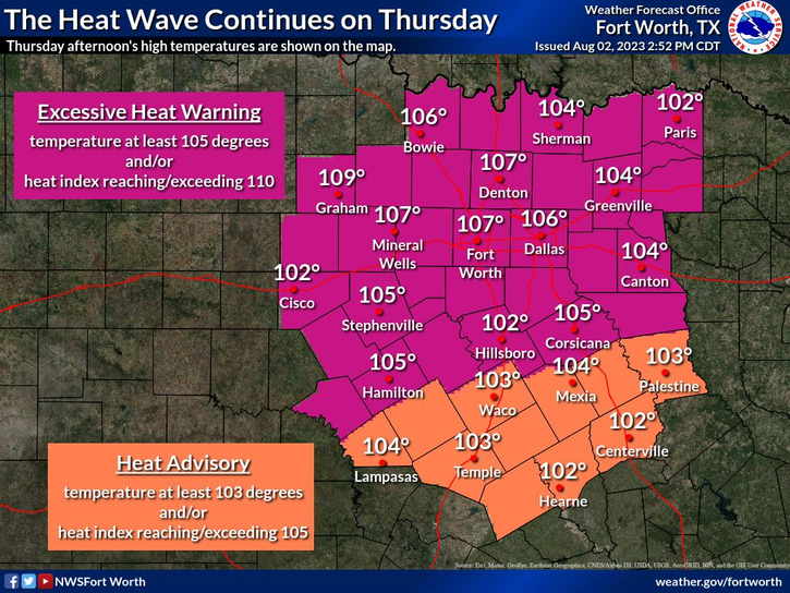

I'm sure all of you are sick and tired of this heat. Unfortunately, the relentless heat will continue five out of the next 7 days across North Texas.
Widespread Excessive Heat Warnings remain in place through Sunday. Yesterday we hit 106° at DFW Airport, we'll hit 106° again today. Also, we're dealing with a high grass fire danger, especially along and west of I-35W. We have two ongoing wildfires across Wise County right now.
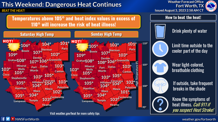
Near record heat invades the area Friday through Sunday with afternoon highs between 106° and 109°. The hottest day will be on Sunday.
This bubble of high pressure in the upper levels of the atmosphere will drift off to the west on Monday and Tuesday, allowing a weak cold front to settle just south of Interstate 20. A couple of weak disturbances will ride the railroad track this front produces, allowing a few scattered showers and storms late Monday and late Tuesday into Wednesday morning. 70% of you will remain dry. Nothing severe is expected. Please remember if you hear thunder, get out of and off of the water.
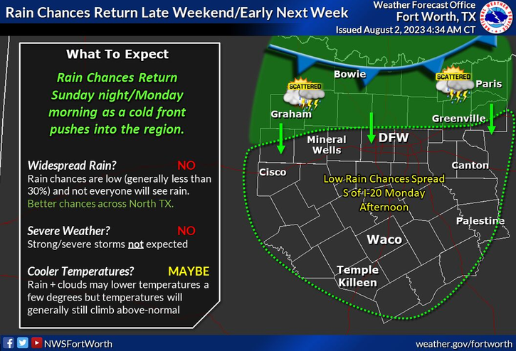
Afternoon highs will only be near 100° on Monday, upper 90s on Tuesday. Unfortunately, this bubble of high pressure returns Wednesday through Friday of next week, as temperatures soar above 100°. There are signs of another cold front that may approach the area by the following weekend.
*Yest Rain: 0.00"; Yest High: 106 Low: 83
*Today’s Averages: High: 97; Low: 77
*Record high: 109 (2011): Record low: 64 (1973)
*August Rain: 0.00"; Deficit: 0.10"
*2023 Rain: 14.83"; Deficit: 7.64"
*Sunrise: 6:43am; Sunset: 8:25pm
Today: *Excessive Heat Warning* Mostly sunny, breezy and hot! High: 106. Grass fire danger. Wind: SSW 10-20 mph.
Tonight: Clear and warm. Low: 78-83. Wind: South 10-20 mph.
Friday: *Excessive Heat Warning * Mostly sunny, breezy and hot. Near record (108) heat. High: 107. Grass fire danger. Wind: SSW 10-20 mph.
Saturday: *Excessive Heat Warning likely* Partly cloudy and hot. Near record (107) heat. High: 107.
Sunday: *Excessive Heat Warning likely* Partly cloudy, continued hot. Near record (109) heat. High: 107-109.
Monday and Tuesday: Partly cloudy and a bit cooler. Isolated showers and storms. Highs: 97-102.
Wednesday. Mostly sunny. Heating back up. High: 105.
Related

LISTEN on the Audacy App
Tell your Smart Speaker to "PLAY 1080 KRLD"
Sign Up to receive our KRLD Insider Newsletter for more news