
Widespread rain, a ton of wind, a slight chance of strong to severe storms Wednesday evening, much colder temperatures to round out the week, and a warming trend this weekend. Those are your weather stories over the next 7 days.
We're waking up to temperatures in the upper 30s to mid 40s with some high clouds passing overhead. Jackets are necessary this morning,
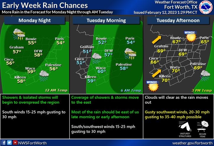
Increasing clouds today with a slight chance of an afternoon shower. Afternoon highs will reach the mid 60s.
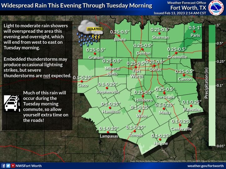
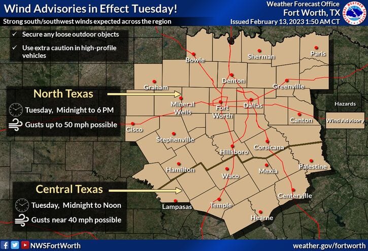
Clouds will thicken up tonight with widespread rain moving in from the west after midnight. Don't be surprised if you hear a rumble of thunder or two through the early morning hours. Nothing severe is expected. Morning lows will drop into the mid 50s with a south wind gusting to 35mph.
Rain will continue through mid morning, with rapid clearing by noon.. A Wind Advisory will also be in effect until 6pm. I wouldn't be surprised to see some wind gusts as high as 50mph!! Afternoon highs will warm to near 70゚.
Wednesday will be partly cloudy and very warm for this time of the year. Daytime highs will reach the mid 70s. By late evening, a strong cold front will be approaching the area. There's a slight chance of a strong and severe storm ahead of the front. As of now, it looks like the best chance for isolated severe storms will be in East Texas.
Thursday will be sunny, very windy, and much colder. Afternoon highs will struggle to get above 45゚. North winds will gust to 35mph.
After a hard freeze Friday morning, temperatures will warm slightly with plenty of sunshine. Readings will top out in the low 50s with less wind.
Another freeze is expected Saturday morning, temperatures will rebound slightly into the upper 50s by afternoon with plenty of sunshine.
Sunday's weather looks nice with passing high clouds. Temperatures will continue to warm. Afternoon highs will reach the upper 60s, with a breezy south wind.
That's all I've got on this chilly Monday morning. Have a terrific day and please enjoy the weather when you can, its the only weather you've got!
7-Day Headlines:
* DFW reached 68 degrees yesterday.
* Rain chances increase tonight into Tuesday morning.
* Wind Advisory Tuesday. Gusts to 50mph possible.
* Slight chance of strong storms late Wednesday.
* Much colder Thursday and Friday.
* Warming up this weekend.
*Yest Rain: 0.00"; High: 68; Low: 34
*Today’s Averages: High: 61; Low: 40
*Record high: 81 (1918); Record low: 1 (1905)
*February Rain: 2.90"; Surplus: 1.86"
*2023 Rain: 4.28"; Surplus: 0.71"
*Sunrise: 7:13am; Sunset: 6:12pm
Looking Ahead:
Today: Increasing clouds and mild. Slight chance of showers. High: Mid 60s. Wind: SSE 10-20 mph.
Tonight: Cloudy and windy. Widespread showers and isolated storms after midnight. Low: Mid 50s. Wind: SSE 20-30, G40 mph.
Valentines Day: *Wind Advisory through 6pm*...Morning rain, afternoon sun. VERY windy! High: Near 70. Wind: SW 20-30, G50 mph.
Wednesday: Increasing clouds, windy and warm. Slight chance of strong to severe storms by evening. Best chance in East Texas. Turning windy and much colder by midnight. High: Mid 70s.
Thursday: Sunny, windy and much colder. High: Mid 40s.
Friday: Sunny and cool. Less wind. High: Low 50s.
Saturday: Passing high clouds and seasonable. High: Upper 50s.
Sunday: Passing high clouds, breezy and warmer. High: Upper 60s.
Related

LISTEN on the Audacy App
Tell your Smart Speaker to "PLAY 1080 KRLD"
Sign Up and Follow NewsRadio 1080 KRLD