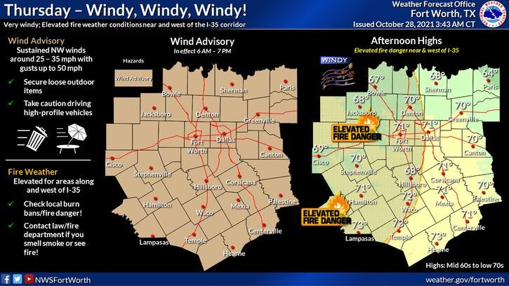

We're starting off very windy this morning with temperatures hovering near 60゚. At 5am, McKinney had a wind gust of 41mph. I wouldn't be surprised to see many areas see gusts to 50 mph by this afternoon. Therefore, a wind advisory is in effect.

What's causing the wind you ask? Well, a strong area of low pressure is in Dixie right now and a strong area of high pressure is nosing its way in from the Great Basin to our northwest. This is causing a tight pressure gradient. This strong gradient will stay in place tonight and tomorrow, so our windy conditions will continue.
Cool air will continue to spill in from the northern and central plain states. Highs today will be near 70゚. Tonight, we'll drop into the upper 40s to low 50s. Tomorrow, to end out our workweek, afternoon highs will reach the upper 60s.
The wind finally relaxes late Friday night and into Saturday. Morning lows Saturday will range from 38゚ to 46゚. Afternoon highs well reach the low seventies with sunshine.
Halloween looks beautiful with daytime highs in the mid to upper 70s... falling into the 60s for the trick-or-treaters during the evening hours.
Our next cold front will take its time coming through the area late Sunday into Monday. Some data holds off the coldest air until late Tuesday and into Wednesday.
I'm going with a slight chance of showers Monday with highs in the low 70s. More scattered showers possible on Tuesday with readings in the mid 60s. It looks like this front will finally plow through the area on Wednesday, as we struggle to get out of the fifties with a chilly rain.
Next week's forecast is subject to change. It depends on how fast the cold front moves through and the track of the upper level disturbances.
*Yest Rain: 0.75”; *Yest High: 78; Low: 60
*Today’s Averages: High: 74; Low: 53
*Record high: 90 (1938); Record low: 30 (1925)
*October rain: 2.96”; October deficit: 0.82"
*2021 Rain: 30.05”; 2021 deficit: 1"
*Sunrise: 7:43am; Sunset: 6:40pm
Today: *Wind Advisory* Sunny, very windy and cool. High: Near 70. Wind: NW 25-35, G 50 mph.
Tonight: Clear, windy and chilly. Low: 48-52. Wind: NW 20-30, G40 mph.
Tomorrow: Sunny, continued windy and cool. High: Mid to upper 60s. Wind: NW 20-30, G35 mph.
Weekend: Sunny, less wind, but still cool. Highs: Low 70s (Sat.); Mid 70s (Halloween).
Monday: Mostly cloudy and cool. Slight chance of rain. High: Mid 70s.
Tuesday: Mostly cloudy and cool. Scattered showers. High: Mid 60s.
Wednesday: Cloudy, windy and chilly. Scattered showers. High: Mid to upper 50s.
Related

LISTEN on the Audacy App
Sign Up and Follow NewsRadio 1080 KRLD