
Happy Valentine's Day! I will promise you this, the rain will be well out of here by the time you head out to dinner with your significant other, that is if you do celebrate Valentine's Day.
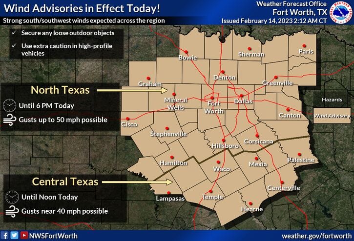
Rain comes to an end before noon, 50 mph wind gusts today with a Wind Advisory in effect, isolated severe storms late tomorrow afternoon and evening, sharply colder for Thursday and Friday, and a warming trend this weekend. Those are your weather stories over the next 7 days.
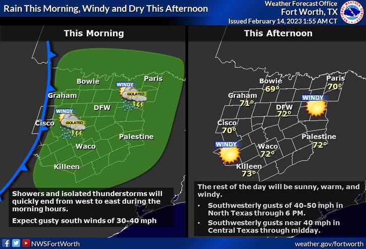
Average rainfall totals out of this morning's event will be around 1/2 of an inch. Rapid clearing will take place close to lunchtime as the wind picks up and gusts to 50 mph through 6pm. Afternoon highs will reach the low seventies.
With dry air in place tonight under a clear sky, temperatures will fall into the low forties. Jackets necessary in the morning.
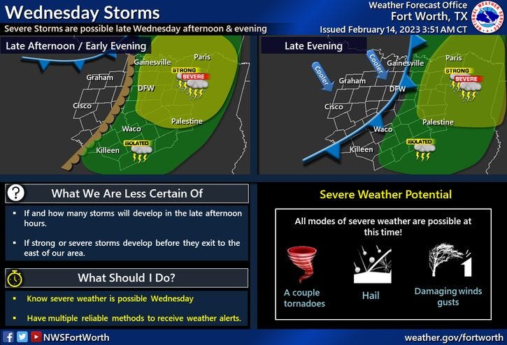
Clouds will increase by late tomorrow afternoon with a chance of some strong to severe storms across north Texas before dinnertime. Only 5-10% of you will see severe storms. The greatest threat for large hail, isolated tornadoes, and damaging wind will be in east Texas.
A strong cold front will plow through the area before you wake up Thursday morning. Thicker coats will be necessary as temperatures will fall into the mid to upper thirties with a north wind gusting to 35 mph. This will create windchills in the twenties Thursday morning. Plenty of sunshine will greet you during the afternoon with a gusty north wind continuing. Windchills will be in the 30s!. Afternoon highs will struggle to hit 45゚.
A hard freeze is expected Friday morning with low temperatures between 25゚ and 30゚, as the wind slowly relaxes.
Friday will be sunny and cool with less wind. Afternoon highs will reach the low fifties. Mid fifties for Saturday, upper sixties for Sunday, and mid to upper seventies by Monday.
Have a terrific Valentine's Day today, enjoy the rain while it lasts and the weather when you can, it's the only weather you've got!
7-Day Headlines:
* DFW reached 66 degrees yesterday.
* Widespread rain with thunder through late morning.
* Clearing bynoon. Wind Advisory today. Gusts to 50 mph possible.
* Slight chance of severe storms late Wednesday.
* Much colder Thursday and Friday.
* Warming up this weekend.
*Yest Rain: 0.00"; High: 66; Low: 41
*Today’s Averages: High: 61; Low: 40
*Record high: 85 (1996); Record low: 9 (2001)
*February Rain: 2.90"; Surplus: 1.76"
*2023 Rain: 4.28"; Surplus: 0.61"
*Sunrise: 7:12am; Sunset: 6:12pm
Looking Ahead:
Valentines Day: Morning rain with thunder, then rapid clearing after lunchtime. **Wind Advisory**...VERY windy and mild. High: Low 70s. Wind: WSW 10-30, G50 mph.
Tonight: Clear and cool. Breezy. Low: Low to mid 40s. Wind: SW 20-30 mph.
Wednesday: Increasing clouds, windy and warm. Slight chance of strong to severe storms late afternoon into the evening. Level 2 out of 5 (slight)for severe storms. Threats: Large hail, damaging wind and isolated tornadoes. Best chance in East Texas. Turning windy and much colder after midnight. High: Mid 70s.
Thursday: Sunny, windy and much colder. High: Mid 40s.
Friday: Sunny and cool. Less wind. High: Low 50s.
Saturday: Passing high clouds and seasonable. High: mid to upper 50s.
Sunday: Passing high clouds, breezy and warmer. High: Upper 60s.
Monday: Partly cloudy, breezy and warm. High: Upper 70s.
Related

LISTEN on the Audacy App
Tell your Smart Speaker to "PLAY 1080 KRLD"
Sign Up and Follow NewsRadio 1080 KRLD