
UPDATE: MONDAY 6PM
Dangerously cold temperatures will be our weather story for the next few days.
We will struggle to get out of the low teens Monday with partial clearing. Bitter cold temperatures overnight tonight with readings between -5 and 0. Sunshine will give way to clouds tomorrow with a high in the mid to upper teens.
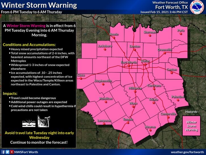
Another Winter Storm Warning is now in effect starting Tuesday at 6 pm through Thursday at 6m for north Texas.
Slow clearing on Thursday after morning flurries with highs in the mid twenties.
Will get very close to freezing with sunshine on Friday and warm into the low 40 Saturday and low fifties on Sunday!
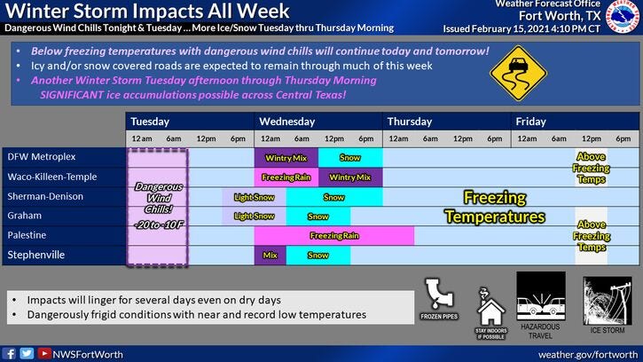
*Winter Storm Warning in effect Tuesday night through Thursday morning*
Monday: Morning flurries, afternoon sun with blowing snow. Windy and bitter cold. High: Near 10. WC near zero. Wind: NNW 15-25 mph.
Monday night: *Hard Freeze Warning* Partly cloudy, breezy. Record cold. Low: Near Zero. WC: Minus 10 - minus 15 degrees. Wind: NNW 10-20 mph.
Tuesday: Partly cloudy early, increasing clouds late day. Breezy and very cold. WINTER STORM WARNING begins at 6 pm. High: Mid to upper teens. Wind: NNE 10-20 mph.
Wed: Cloudy and continued cold. Storm #2 arrives. Chance of accumulating snow. High: Low 20s.
Thursday: Decreasing clouds, continued cold. High: Mid to upper 20s.
Friday: Sunny and chilly. A slow warm up. High: Low to mid 30s.
Weekend: Warming up and thawing out! Plenty of sunshine! Highs: Saturday: Mid 40s; Sunday: Mid 50s!