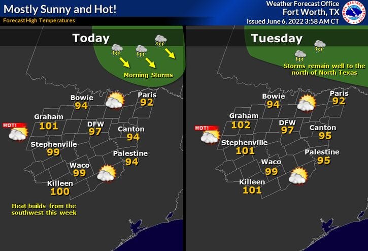

Good morning my friends and welcome to Monday! Another weekend just blew on by and temperatures weren't too bad for this time of the year. Our average high temperature is now 90° so get used to 90 degree weather all week long. We might even inch towards the 100° mark by Friday.
We're waking up the temperatures in the mid-seventies this morning with a south wind gusting to 25 mph. I've been watching a complex of storms since late last night across Central Kansas. Unfortunately, the trajectory of these storms will take them into Arkansas this morning. This being said, more storms will continue to fire across the Central Plains states through the rest of the week. As of now, I'm thinking these storms will miss the Dallas-Fort Worth area tomorrow, Wednesday, and Thursday morning. However, they may become ominously close to DFW Thursday and Friday morning. Residents across the Red River Valley may hear some noise each morning. Please keep in mind, there's a very slight chance some of these storms could inch just north of the Dallas-Fort Worth area as well, but doubtful.
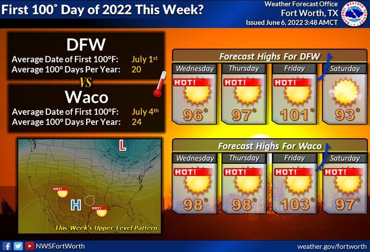
Afternoon highs today through Thursday will reach the mid-to-upper 90s. Factor in the humidity, it'll feel more like 102 degrees to 104 degrees. Please make sure you take necessary precautions if you're going to be working outdoors... Water, water, water!
By late Friday, a weak cold front will inch its way through the area by evening. There's a slight chance of storms along this front. It's still days away but needs to be monitored.
A slight cool-down is expected on Saturday with slightly lower humidity. High temperatures will be in the low 90s.
Unfortunately, the brief break in the heat won't last long, because we're going to be well up into the 90s and probably in the hundreds the following week.
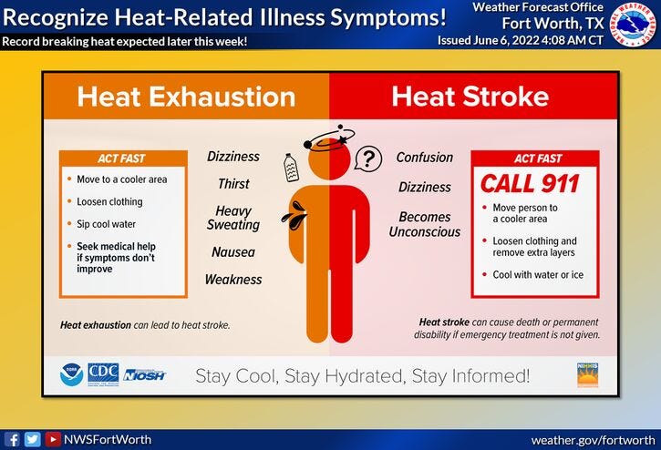
This all being said, please know the difference between heat exhaustion and heat stroke. Heat stroke is much worse than heat exhaustion. If you're around anybody that has a high fever or loses consciousness, please call 911 immediately. They are suffering from heat stroke.
*Yest Rain: 0.00”; *Yest High: 93; Low: 73
*Today’s Averages: High: 90; Low: 71
*Record high: 101 (1948, 1977); Record low: 55 (1970)
* June rain: 2.64”; June surplus: +1.97”
*2022 rain: 12.41”; 2022 deficit: 4.85"
*Sunrise: 6:20am; Sunset: 8:24pm
Today: Morning clouds, afternoon sun. Windy and hot. High: Mid to upper 90s. Heat index 102. Wind: South 15-25, G30 mph.
Tonight: Fair, mild and muggy. Low: Mid to upper 70s. Wind: South 15-25 mph.
Tomorrow: Morning clouds, afternoon sun. Windy and hot. High: Upper 90s. Heat index 102. Wind: SSE 10-20, G25 mph.
Wednesday and Thursday: Morning clouds, afternoon sunshine. HOT! . High: Mid 90s. Heat index 102
Friday: Mostly sunny and VERY hot. Slight chance of a late evening storm. Highs: Near 100.
Saturday: Partly cloudy and not as hot. High: Low 90s.
Sunday: Mostly sunny. Heating back up. Highs: Mid 90s.
Related

LISTEN on the Audacy App
Sign Up and Follow NewsRadio 1080 KRLD