
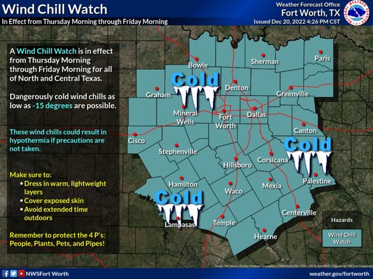
A Wind Chill Watch is in effect from Thursday morning through Friday morning for all of our North and Central Texas counties. Frigid ambient temperatures and strong winds will allow for dangerously cold wind chills as low as -15 degrees to be possible. These wind chills could result in hypothermia if precautions are not taken. Make sure to avoid extended time outdoors if possible, and if you have to brave the cold, then dress in warm, lightweight layers and cover exposed skin. Bring in pets and any sensitive outdoor plants (if possible), and to cover outdoor pipes.
Drizzle and fog, some peaks of sunshine, winter arrives Wednesday, and an Arctic blast makes us miserable for a few days. Those are your weather stories as we approach Christmas Day.
We're waking up to temperatures in the low to mid-40s with some areas of light rain and drizzle dotting north Texas. Enough to wet the roadways. Partial clearing is expected by afternoon as temperatures warm into the low 50s.
Winter arrives tomorrow at 3:48 p.m.! We'll start the day off in the mid 30s under a partly cloudy sky. A mix of clouds will greet you during the day with highs back in the low 50s.
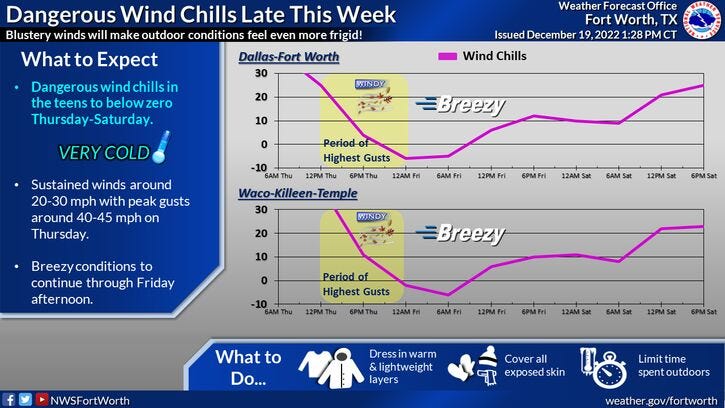
You still have some time to winterize your homes and vehicles before the Arctic blast arrives mid-morning Thursday. We'll start off the morning in the upper 30s to low 40s with increasing clouds. The Arctic cold front will plow through the area before noon, dropping temperatures to near 20° by early afternoon. Factor in the 40 plus mph wind gusts, wind chills will fall into the single digits during the day.
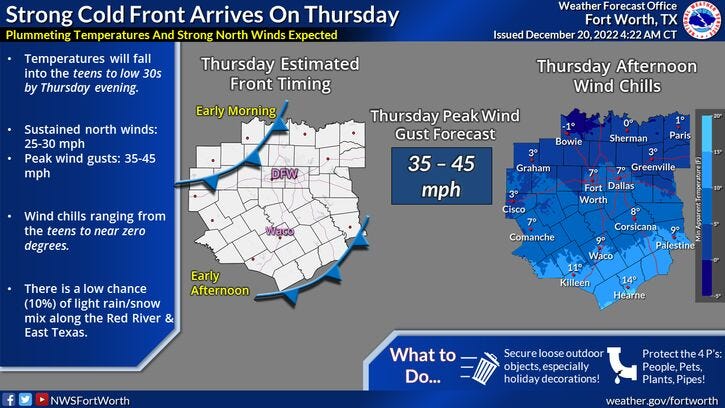
There's also a very slight chance of a wintry mix or some flurries around north Texas from late morning through the afternoon but no accumulations are expected. Temperatures will continue to tumble into Friday morning. I'm expecting low temperatures to range 8 and 12°, with wind chills slightly below zero. Pets, pipes, plants, people! 4 P's y'all!
We won't warm up much on Friday, as temperatures creep into the low to mid 20s. North winds will continue to gust to 30 mph. Wind chills will be in the low teens.
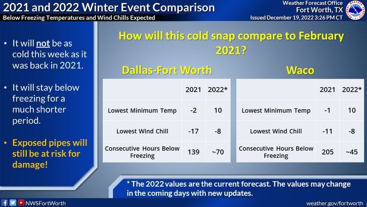
Christmas Eve Day calls for a mix of sun and clouds with high temperatures approaching the freezing mark. We'll drop back into the mid 20s on Christmas morning, with highs warming up to near 40°. Our warmup will continue into early next week -- 50s by Monday! The best news out of the weather change: it won't last long, nothing like February of 2021.
Have a terrific day today and please enjoy the weather when you can, it's the only weather you've got!

7-Day Headlines:
* DFW reached 49 degrees yesterday.
* Decent weather today and Wednesday.
* "Blue Norther" arrives mid morning Thursday.
* 40s early, low 20s after lunch, teens by evening.
* Below zero wind chills into Friday morning.
* Cold through Christmas, warming next week.
*Yest Rain: Trace; High: 49; Low: 45
*Today’s Averages: High: 57; Low: 37
*Record high: 79 (2010); Record low: 8 (1924)
*December rain: 2.38"; Surplus: 0.65"
*2022 Rain: 36.63”; 2022 Surplus 0.73"
*Sunrise: 7:26am; Sunset: 5:25pm
Looking Ahead:
Today: Morning fog/drizzle, peeks of afternoon sun. High: Low 50s. Wind: NE 5-10 mph.
Tonight: Partly cloudy and chilly. Low: Mid to upper 30s. Wind: NNE 5-10 mph.
Tomorrow: Winter arrives at 3:48pm. Partly cloudy and cool. High: Low 50s. Wind: SSE 5-10 mph.
Thursday: Increasing clouds, turning very windy and sharply colder by late morning. A slight chance of a wintry mix or flurries through the afternoon. No accumulations expected. Temps: Low 40s early, falling through the 20s. Wind chills in the single digits. Wind: NNW 25-35, G45mph.
Friday: Sunny, windy and cold. Low: 7-12 degrees; High: Mid 20s.
Saturday: Partly cloudy, continued cold. Low: Low 20s; High: Low 30s.
Christmas Day: Mostly sunny and a bit warmer. High: Near 40.
Monday: Sunny with a continued warm up. High: Low to mid 50s.
Related

LISTEN on the Audacy App
Tell your Smart Speaker to "PLAY 1080 KRLD"
Sign Up and Follow NewsRadio 1080 KRLD