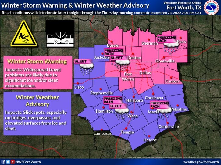

Parts of North Texas are seeing light to moderate freezing drizzle Thursday morning as temperatures have remained in the low 20s.

As an upper-level disturbance approaches later Thursday morning, there will be an enhancement of frozen precipitation along and east of Interstate 35W. Light freezing rain, with some sleet, will fall. Temperatures will be well below freezing, so the roads will get worse before they get better this afternoon.
Precipitation will end from west to east early this afternoon and road conditions will drastically improve. Temperatures will creep close to the freezing mark as well, slightly above freezing west of I-35W where skies may partially clear before sunset.
Temperatures will fall quickly Thursday night under a clear sky. Readings will range from 18-22 degrees.
Friday will start with sunshine. Afternoon highs will be much warmer. How do the low to mid 40s sound? Heck yeah! The sunshine will be brief on Friday, clouds will rapidly increase Friday night ahead of our next upper-level disturbance. Precipitation in the form of light freezing rain or even some light snow will start to break out just north and west of the Dallas-Fort Worth area Saturday morning, where temperatures will be slightly below freezing. I'm not looking for a big impact on roadways though. A chilly rain will fall elsewhere Saturday morning through the afternoon. Temperatures will struggle to hit 40 degrees.
This disturbance moves east into Sunday. Skies will clear and temperatures will warm up into the low to mid-50s. That sounds inviting!
If you like Sunday, you'll really love next Monday through Wednesday. Heck, temperatures will be above 70 by midweek!
In closing, please hold off traveling until after the noon hour today. That's when road conditions will drastically improve.
*Yest Rain: 0.08”; *Yest High: 33; Low: 23
*Today’s Averages: High: 63; Low: 42
*Record high: 93 (1918); Record low: 15 (1910)
*February rain: 2.01”; February deficit: 0.17"
*2022 Rain: 2.01”; 2022 deficit: 2.62"
*Sunrise: 7:02am; Sunset: 6:21pm
*Winter Storm Warning until 6pm Thursday, DFW -> north*
*Winter Weather Advisory until 6pm, surrounding areas.
Thursday: Cloudy and cold. Pockets of light freezing rain/freezing drizzle through early afternoon. High: 32 East; 36 West. Wind: North 10-15 mph.
Thursday night: Clear and cold. Low: 17-22. Wind: North 10-15 mph.
Friday: Mostly sunny, breezy and chilly. Increasing clouds toward evening. High: Near Mid 40s. Wind: NNE 15-25 mph.
Friday night: Cloudy and cold. Low: 28-34.
Saturday: Morning freezing rain/rain, afternoon light cold rain. Continued cold. High: Upper 30s.
Sunday: Decreasing clouds and warmer. High: Low to mid 50s.
Monday: Sunny and perfect. High: Low to mid 60s.
Tuesday: Sunny and nice. High: Near 70.
Wednesday: Sunny and awesome. High: Low 70s.
Related

LISTEN on the Audacy App
Sign Up and Follow NewsRadio 1080 KRLD